File:Peleliu State map-fr.svg
Jump to navigation
Jump to search

Size of this PNG preview of this SVG file: 596 × 599 pixels. Other resolutions: 239 × 240 pixels | 477 × 480 pixels | 764 × 768 pixels | 1,019 × 1,024 pixels | 2,037 × 2,048 pixels | 2,455 × 2,468 pixels.
Original file (SVG file, nominally 2,455 × 2,468 pixels, file size: 490 KB)
Captions
Captions
Add a one-line explanation of what this file represents
Summary
[edit]
| Description |
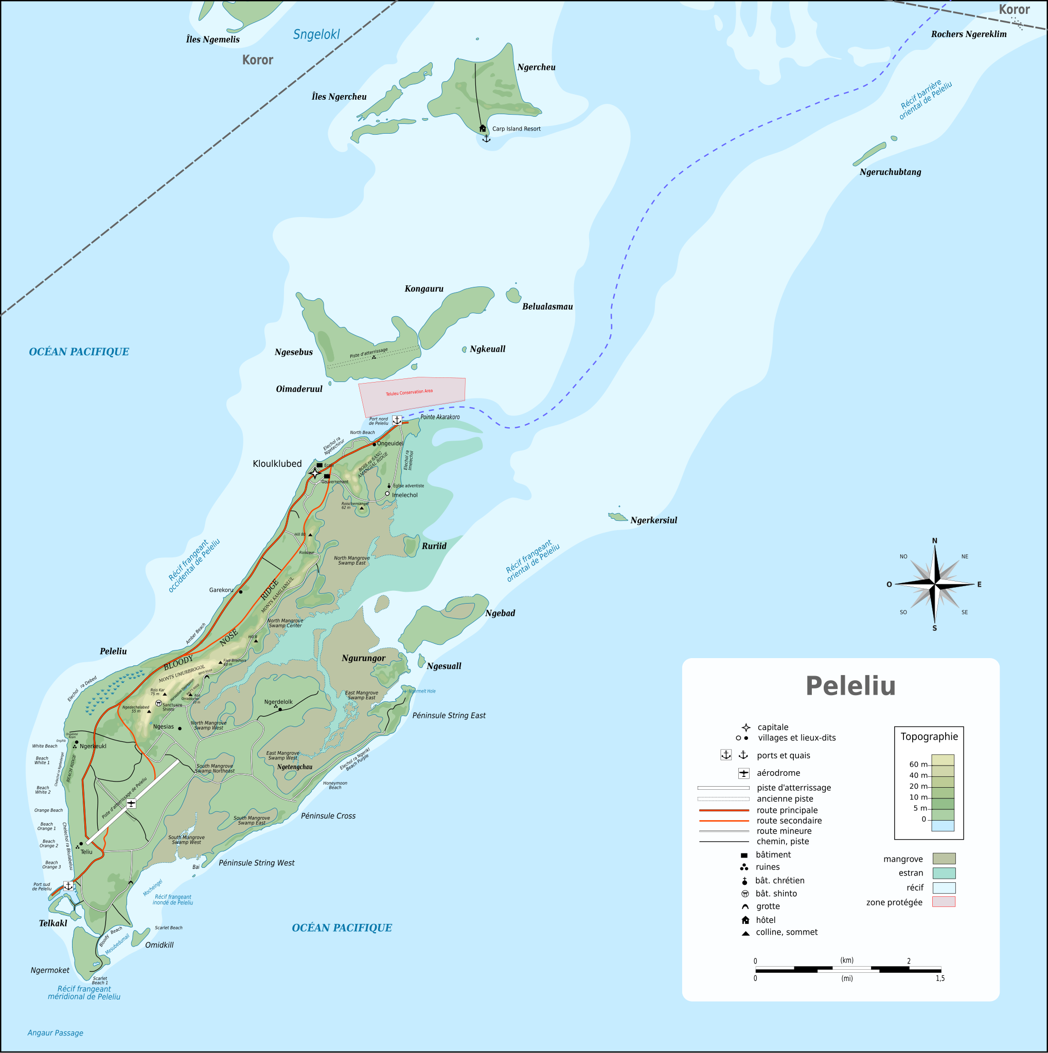
Français : Carte de l’État de Peleliu aux Palaos, basée sur :
|
| Date | |
| Source | Own work |
| Author | Treehill |
Licensing
[edit]
I, the copyright holder of this work, hereby publish it under the following license:
This file is licensed under the Creative Commons Attribution-Share Alike 4.0 International license.
- You are free:
- to share – to copy, distribute and transmit the work
- to remix – to adapt the work
- Under the following conditions:
- attribution – You must give appropriate credit, provide a link to the license, and indicate if changes were made. You may do so in any reasonable manner, but not in any way that suggests the licensor endorses you or your use.
- share alike – If you remix, transform, or build upon the material, you must distribute your contributions under the same or compatible license as the original.
File history
Click on a date/time to view the file as it appeared at that time.
| Date/Time | Thumbnail | Dimensions | User | Comment | |
|---|---|---|---|---|---|
| current | 11:31, 16 November 2017 | | 2,455 × 2,468 (490 KB) | Treehill (talk | contribs) | Update Ngabad |
| 12:09, 17 October 2017 |  | 2,455 × 2,468 (489 KB) | Treehill (talk | contribs) | + toponyms | |
| 12:01, 17 October 2017 |  | 2,455 × 2,468 (488 KB) | Treehill (talk | contribs) | + legends | |
| 09:40, 17 October 2017 |  | 2,455 × 2,468 (486 KB) | Treehill (talk | contribs) | + a few toponyms | |
| 10:25, 12 October 2017 |  | 2,455 × 2,468 (483 KB) | Treehill (talk | contribs) | + legend | |
| 09:45, 12 October 2017 |  | 2,455 × 2,468 (434 KB) | Treehill (talk | contribs) | +roads | |
| 08:50, 12 October 2017 |  | 2,455 × 2,468 (393 KB) | Treehill (talk | contribs) | more toponyms | |
| 08:48, 12 October 2017 |  | 2,452 × 2,348 (380 KB) | Treehill (talk | contribs) | + names | |
| 10:11, 11 October 2017 |  | 2,452 × 2,348 (318 KB) | Treehill (talk | contribs) | some corrections | |
| 20:20, 10 October 2017 |  | 2,452 × 2,348 (1,000 KB) | Treehill (talk | contribs) | -black square |
You cannot overwrite this file.
File usage on Commons
The following page uses this file:
File usage on other wikis
The following other wikis use this file:
- Usage on ceb.wikipedia.org
- Usage on de.wikipedia.org
- Usage on fr.wikipedia.org
- Peleliu (île)
- État de Peleliu
- Ngercheu
- Ngesebus
- Ngurungor
- Kongauru
- Ngebad
- Belualasmau
- Îles Ngercheu
- Ngerkersiul
- Ngeruchubtang
- Ngesuall
- Ngetengchau
- Ngkeuall
- Oimaderuul
- Ruriid
- Rois Kar
- Bloody Nose Ridge
- Amangial Ridge
- Beach Ridge
- Ngerdelolk
- Ngesias
- Ngerchol
- Ngerkeukl
- Teliu (Palaos)
- Roischemiangel
- Five Brothers
- Ngedechelabed
- Rois Omleblochel
- Hill 80
- Omidkill
- Rochers Ngereklim
- Aérodrome de Peleliu
- Marais à mangrove septentrional
- Marais à mangrove oriental
- Marais à mangrove méridional
- Usage on www.wikidata.org