File:Pelješac bridge location map.svg
Jump to navigation
Jump to search

Size of this PNG preview of this SVG file: 800 × 491 pixels. Other resolutions: 320 × 196 pixels | 640 × 393 pixels | 1,024 × 628 pixels | 1,280 × 785 pixels | 2,560 × 1,571 pixels | 1,097 × 673 pixels.
Original file (SVG file, nominally 1,097 × 673 pixels, file size: 810 KB)
Captions
Captions
Add a one-line explanation of what this file represents
Summary
[edit]
| Description |
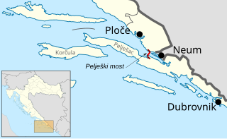
English: location map of Pelješac Bridge (red), avoiding Bosnia and Herzegovina territory for connection of Dubrovnik with the rest of Croatia Deutsch: Lage der Pelješac-Brücke (rot), welche eine Verbindung zwischen Dubrovnik und dem Rest von Kroatien erstellt ohne durch Bosnien und Herzegowina zu führen. |
| Date | |
| Source |
This file was derived from: Neum strip location map.svg: |
| Author |
|
Licensing
[edit]
I, the copyright holder of this work, hereby publish it under the following license:
This file is licensed under the Creative Commons Attribution-Share Alike 3.0 Unported license.
- You are free:
- to share – to copy, distribute and transmit the work
- to remix – to adapt the work
- Under the following conditions:
- attribution – You must give appropriate credit, provide a link to the license, and indicate if changes were made. You may do so in any reasonable manner, but not in any way that suggests the licensor endorses you or your use.
- share alike – If you remix, transform, or build upon the material, you must distribute your contributions under the same or compatible license as the original.
Original upload log
[edit]
This image is a derivative work of the following images:
- File:Neum_strip_location_map.svg licensed with Cc-by-sa-3.0
- 2012-05-08T15:25:17Z Tomobe03 1097x673 (826851 Bytes)
Uploaded with derivativeFX
File history
Click on a date/time to view the file as it appeared at that time.
| Date/Time | Thumbnail | Dimensions | User | Comment | |
|---|---|---|---|---|---|
| current | 20:41, 22 February 2014 | | 1,097 × 673 (810 KB) | Pechristener (talk | contribs) | Diesmal sollte es klappen mit der Schrift |
| 20:34, 22 February 2014 |  | 1,097 × 673 (810 KB) | Pechristener (talk | contribs) | ein Teil der Beschriftung war verloren gegangen | |
| 20:31, 22 February 2014 |  | 1,097 × 673 (2.44 MB) | Pechristener (talk | contribs) | == {{int:filedesc}} == {{Information |Description={{en|1=location map of Pelješac Bridge (red), avoiding Bosnia and Herzegovina territory for connection of Dubrovnik with the rest of Croatia}}{{de|1=Lage der [[:de:Pelješac-Br... |
You cannot overwrite this file.
File usage on Commons
The following 2 pages use this file:
File usage on other wikis
The following other wikis use this file:
- Usage on ar.wikipedia.org
- Usage on bs.wikipedia.org
- Usage on de.wikipedia.org
- Usage on en.wikipedia.org
- Usage on eo.wikipedia.org
- Usage on es.wikipedia.org
- Usage on fi.wikipedia.org
- Usage on fr.wikipedia.org
- Usage on he.wikipedia.org
- Usage on hr.wikipedia.org
- Usage on ja.wikipedia.org
- Usage on pl.wikipedia.org
- Usage on sl.wikipedia.org
- Usage on sq.wikipedia.org
- Usage on sv.wikipedia.org
- Usage on uk.wikipedia.org
- Usage on www.wikidata.org
- Usage on zh.wikipedia.org