File:Pemulwuy Aerial Photo.jpg
Jump to navigation
Jump to search

Size of this preview: 800 × 534 pixels. Other resolutions: 320 × 213 pixels | 640 × 427 pixels | 1,024 × 683 pixels | 1,280 × 854 pixels | 2,560 × 1,708 pixels | 4,000 × 2,668 pixels.
Original file (4,000 × 2,668 pixels, file size: 4.66 MB, MIME type: image/jpeg)
Captions
Captions
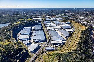
An aerial photo of Pemulwuy, taken from the south.
Summary[edit]
| Description |
English: An aerial photo, taken from a helicopter. The industrial area of Pemulwuy in the western suburbs of Sydney Australia, was built in a previous quarry.
This photo was taken looking south to north, from an altitude of 369m or approx 1200 feet. |
| Date | |
| Source | Own work |
| Author | Mark Merton |
| Camera location | | View this and other nearby images on: OpenStreetMap |
|---|
Licensing[edit]
I, the copyright holder of this work, hereby publish it under the following license:
This file is licensed under the Creative Commons Attribution-Share Alike 4.0 International license.
- You are free:
- to share – to copy, distribute and transmit the work
- to remix – to adapt the work
- Under the following conditions:
- attribution – You must give appropriate credit, provide a link to the license, and indicate if changes were made. You may do so in any reasonable manner, but not in any way that suggests the licensor endorses you or your use.
- share alike – If you remix, transform, or build upon the material, you must distribute your contributions under the same or compatible license as the original.
File history
Click on a date/time to view the file as it appeared at that time.
| Date/Time | Thumbnail | Dimensions | User | Comment | |
|---|---|---|---|---|---|
| current | 03:38, 17 May 2023 | | 4,000 × 2,668 (4.66 MB) | Sydney Images (talk | contribs) | Uploaded own work with UploadWizard |
You cannot overwrite this file.
File usage on Commons
There are no pages that use this file.