File:Penang Island heightmap ASTGTM2 N05E100 dem.png
跳去導覽
跳去搵嘢
預覽大細:400 × 600 像素。 第啲解像度:160 × 240 像素 | 620 × 930 像素。
原本檔案 (620 × 930 像素,檔案大細:351 KB ,MIME類型:image/png)
Captions
Captions
Add a one-line explanation of what this file represents
摘要[編輯]
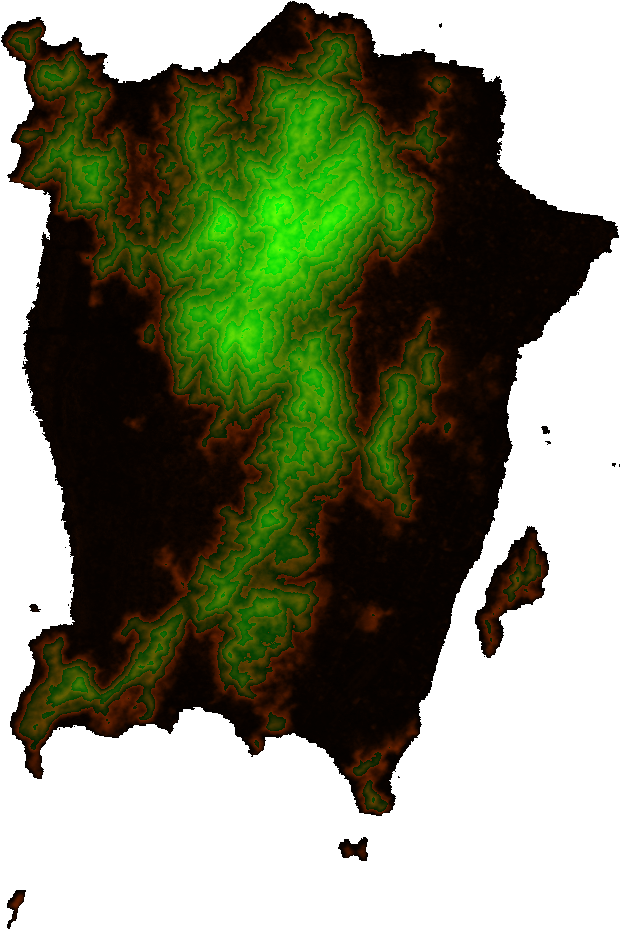
| 描述 |
English: A heightmap of Penang Island and surrounding islands with contour discontinuities every 100 m, plotted from ASTER Global Digital Elevation Model data at http://step.esa.int/auxdata/dem/SRTMGL1 and coloured as follows:
|
||
| 來源 | 自己作品 | ||
| 作者 | Cmglee | ||
| Other versions |
|


協議[編輯]
I, the copyright holder of this work, hereby publish it under the following licenses:
呢個檔案用共享創意 姓名標示-非商業性-相同方式分享3.0 未本地化版本條款授權。
- 你可以:
- 去分享 – 複製、發佈同傳播呢個作品
- 再改 – 創作演繹作品
- 要遵照下面嘅條件:
- 署名 – 你一定要畀合適嘅表彰、畀返指向呢個授權條款嘅連結,同埋寫明有無改過嚟。你可以用任何合理方式去做,但唔可以用任何方式暗示授權人認可咗你或者你嘅使用方式。
- 相同方式分享 – 如果你用任何方式改過呢個作品,你必須要用返原本或者相似嘅條款發佈。

|
根據自由軟體基金會發佈嘅無固定段落、封面文字同封底文字GNU自由文件授權條款第1.2或打後嘅版本,你獲授權可以重製、散佈同埋修改爾份文件。授權條款嘅副本喺章節GNU自由文件授權條款。 |
你可以揀你想用嘅牌照。
檔案歷史
撳個日期/時間去睇響嗰個時間出現過嘅檔案。
| 日期/時間 | 縮圖 | 尺寸 | 用戶 | 註解 | |
|---|---|---|---|---|---|
| 現時 | 2013年10月18號 (五) 23:00 | | 620 × 930(351 KB) | Cmglee(傾偈 | 貢獻) | Update to decimal version where Height in m = 100 × Blue + Red |
| 2013年10月18號 (五) 22:32 |  | 620 × 930(336 KB) | Cmglee(傾偈 | 貢獻) | {{Information |Description ={{en|1=A heightmap of Penang Island and surrounding islands plotted from data from the ASTER GDEM system at http://gdem.ersdac.jspacesystems.or.jp/download.jsp and coloured as follows: * Alpha channel: Height of 0 m (sea... |
你無得衾咗個檔案。
檔案用途
以下嘅4版用到呢個檔:
全域檔案使用情況
下面嘅維基都用緊呢個檔案:
- ar.wikipedia.org嘅使用情況
- bn.wikipedia.org嘅使用情況
- en.wikipedia.org嘅使用情況
- gl.wikipedia.org嘅使用情況
- ur.wikipedia.org嘅使用情況
- vi.wikipedia.org嘅使用情況
- www.wikidata.org嘅使用情況
- zh-yue.wikipedia.org嘅使用情況