File:Penton Hook and Savory's Weir.jpg
Jump to navigation
Jump to search

Size of this preview: 668 × 600 pixels. Other resolutions: 267 × 240 pixels | 535 × 480 pixels | 855 × 768 pixels | 1,140 × 1,024 pixels | 1,619 × 1,454 pixels.
Original file (1,619 × 1,454 pixels, file size: 353 KB, MIME type: image/jpeg)
Captions
Captions
Add a one-line explanation of what this file represents
Summary
[edit]| Map of Middlesex | |
|---|---|
| Author |
Ordnance Survey |
| Title |
Map of Middlesex |
| Description |
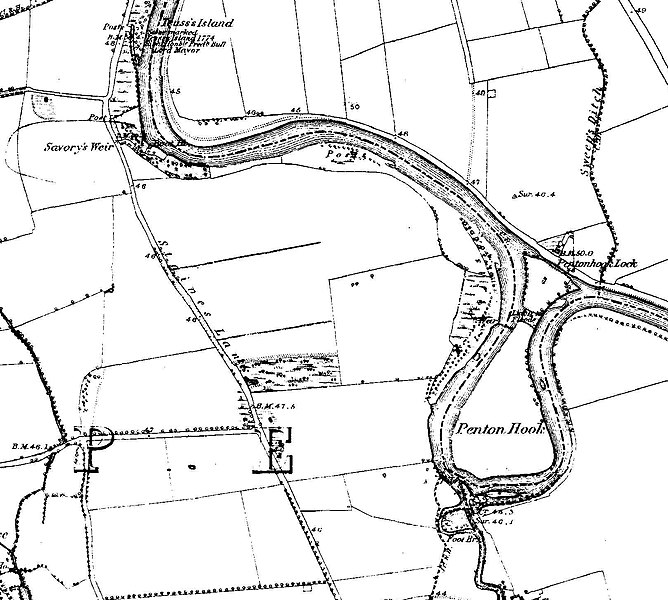
English: Sheet 024 Ashford, Chertsey, Egham, Englefield Green, Laleham, Littleton, Lyne, Shepperton, Staines, Stroude, Thorpe, Thorpe Green, Thorpe Lea, Trumps Green, Virginia Water, TW15 2, KT16 9, TW20 9, TW20 0, TW18 2, TW17 0, KT16 0, TW17 9, TW18 3, GU25 4, TW20 8 |
| Date | between 1868 and 1883 |
| Source/Photographer | http://www.british-history.ac.uk/os-1-to-10560/middlesex/024 |
| Other versions | |

Licensing
[edit]
|
This is a faithful photographic reproduction of a two-dimensional, public domain work of art. The work of art itself is in the public domain for the following reason:
The official position taken by the Wikimedia Foundation is that "faithful reproductions of two-dimensional public domain works of art are public domain".
This photographic reproduction is therefore also considered to be in the public domain in the United States. In other jurisdictions, re-use of this content may be restricted; see Reuse of PD-Art photographs for details. | ||||
File history
Click on a date/time to view the file as it appeared at that time.
| Date/Time | Thumbnail | Dimensions | User | Comment | |
|---|---|---|---|---|---|
| current | 13:07, 9 July 2019 | | 1,619 × 1,454 (353 KB) | Belbury (talk | contribs) | File:Map of Middlesex Sheet 024, Ordnance Survey, 1868-1883.jpg cropped 85 % horizontally, 80 % vertically using CropTool with lossless mode. |
You cannot overwrite this file.
File usage on Commons
The following 2 pages use this file:
File usage on other wikis
The following other wikis use this file:
- Usage on en.wikipedia.org