File:Ph map laspinas.png
跳转到导航
跳转到搜索
本预览的尺寸:457 × 599像素。 其他分辨率:183 × 240像素 | 600 × 787像素。
原始文件 (600 × 787像素,文件大小:59 KB,MIME类型:image/png)
说明
说明
添加一行文字以描述该文件所表现的内容
摘要
[编辑]| 描述 |
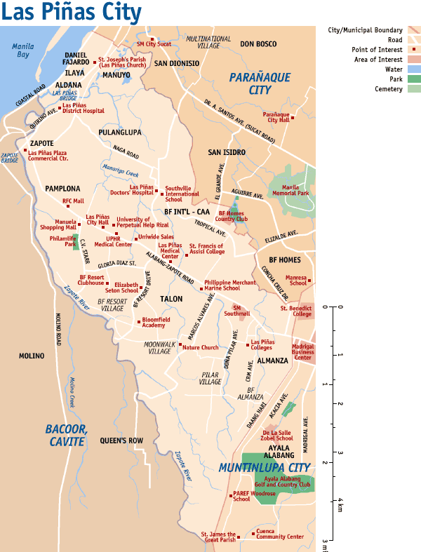
English: Map of Las Piñas in Metro Manila, Philippines. |
||||
| 日期 | |||||
| 来源 | 自己的作品 | ||||
| 作者 | Eugene Alvin Villar (seav) | ||||
| 授权 (二次使用本文件) |
我,本作品著作权人,特此采用以下许可协议发表本作品:
您可以选择您需要的许可协议。
|


文件历史
点击某个日期/时间查看对应时刻的文件。
| 日期/时间 | 缩略图 | 大小 | 用户 | 备注 | |
|---|---|---|---|---|---|
| 当前 | 2005年9月3日 (六) 17:23 | | 600 × 787(59 KB) | Magalhães(留言 | 贡献) | Map of Las Piñas City, Philippines. The map shows major roads, and many points of interest in the city. Category: Maps of Metro Manilla |
您不可以覆盖此文件。
文件用途
没有页面使用本文件。
全域文件用途
以下其他wiki使用此文件: