File:Ph regions and provinces.svg
Spring til navigation
Spring til søgning

Size of this PNG preview of this SVG file: 412 × 599 pixels. Andre opløsninger: 165 × 240 pixels | 330 × 480 pixels | 528 × 768 pixels | 704 × 1.024 pixels | 1.409 × 2.048 pixels | 4.200 × 6.105 pixels.
Oprindelig fil (SVG fil, basisstørrelse 4.200 × 6.105 pixels, filstørrelse: 2,97 MB)
Captions
Captions
Tilføj en kort forklaring på en enkelt linje om hvad filen viser
Beskrivelse
[redigér]| Beskrivelse |
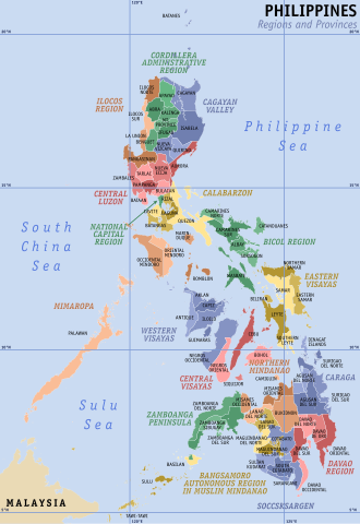
English: Map of the Philippines showing the location of all the regions and provinces.
Notes: The map does not depict cities that are independent of any province. It also does not depict the status of Sabah, the Spratly Islands, and Scarborough Shoal as disputed Philippine territories. |
| Dato | |
| Kilde | Own work, based on seav's Ph regions and provinces.png and Felipe Aira's File:PhlMapCit.svg |
| Forfatter | HueMan1 |
| Andre versioner |
|

Licensering
[redigér]
HueMan1, dette værks ophavsretsindehaver, udgiver hermed værket under den følgende licens:

|
Tilladelse er givet til at kopiere, distribuere og/eller ændre dette dokument under betingelserne i GNU Free Documentation License', Version 1.2 eller enhver senere version udgivet af Free Software Foundation; uden et invariant afsnit, ingen forsidetekster, og ingen bagsidetekst. En kopi af licensen er inkluderet i afsnittet GNU Free Documentation License. |
Filhistorik
Klik på en dato/tid for at se filen som den så ud på det tidspunkt.
| Dato/tid | Miniaturebillede | Dimensioner | Bruger | Kommentar | |
|---|---|---|---|---|---|
| nuværende | 23. jul. 2023, 05:49 | | 4.200 × 6.105 (2,97 MB) | Hariboneagle927 (diskussion | bidrag) | + Maguindanao division |
| 11. mar. 2023, 23:58 |  | 4.200 × 6.105 (2,95 MB) | Hariboneagle927 (diskussion | bidrag) | Bangsamoro SGA in Cotabato (since Lamitan is shown as part of Zamboanga Peninsula in this map) | |
| 10. dec. 2019, 15:58 |  | 4.200 × 6.105 (2,94 MB) | HueMan1 (diskussion | bidrag) | Renamed Compostela Valley to Davao de Oro. | |
| 9. aug. 2019, 05:09 |  | 4.200 × 6.105 (2,95 MB) | HueMan1 (diskussion | bidrag) | Minor fixes | |
| 19. jul. 2019, 12:26 |  | 4.200 × 6.105 (2,95 MB) | HueMan1 (diskussion | bidrag) | Minor fixes | |
| 1. jul. 2019, 10:10 |  | 4.200 × 6.105 (2,95 MB) | HueMan1 (diskussion | bidrag) | User created page with UploadWizard |
Du kan ikke overskrive denne fil.
Filanvendelse
De følgende 2 sider bruger denne fil:
Global filanvendelse
Følgende andre wikier anvender denne fil:
- Anvendelser på an.wikipedia.org
- Anvendelser på bcl.wikipedia.org
- Anvendelser på be-tarask.wikipedia.org
- Anvendelser på el.wikipedia.org
- Anvendelser på en.wikipedia.org
- Mindanao
- Philippines
- Spratly Islands
- Luzon
- Metro Manila
- Visayas
- Provinces of the Philippines
- Manila
- Barangay
- Regions of the Philippines
- Cities of the Philippines
- Wikipedia:WikiProject Philippine LGUs/Province template
- Municipalities of the Philippines
- Southern Tagalog
- Quezon City
- Lanao del Sur
- Autonomous Region in Muslim Mindanao
- Valenzuela, Metro Manila
- Kalayaan, Palawan
- List of cities and municipalities in the Philippines
- Portal:Philippines
- Administrative divisions of the Philippines
- Template:Administrative divisions of the Philippines
- Portal:Philippines/Topics
- Territories claimed by the Philippines
- Legislative districts of the Philippines
- Talk:Philippines/Archive 7
- Internal Revenue Allotment
- Outline of the Philippines
- Wikipedia talk:Tambayan Philippines/Archive 16
- Barangay captain
- List of primary local government units of the Philippines
- Template:English official language clickable map/testcases
- Partido (historical province)
- Barangay hall
- Bangsamoro
- Barangay elections
- Negros
- User:Dgfddfgs/sandbox
- Autonomous regions of the Philippines
- User:Sanglahi86/sandbox
- Negros Island Region
- Sub-provinces of the Philippines
- User:Jcisawesomeguy/sandbox
- Special Geographic Area
- Caburacanan
Vis flere globale anvendelser af denne fil.