File:Ph regions and provinces.svg
ナビゲーションに移動
検索に移動

この SVG ファイルのこの PNG プレビューのサイズ: 412 × 599 ピクセル. その他の解像度: 165 × 240 ピクセル | 330 × 480 ピクセル | 528 × 768 ピクセル | 704 × 1,024 ピクセル | 1,409 × 2,048 ピクセル | 4,200 × 6,105 ピクセル。
元のファイル (SVG ファイル、4,200 × 6,105 ピクセル、ファイルサイズ: 2.97メガバイト)
キャプション
キャプション
このファイルの内容を1行で記述してください
概要
[編集]| 解説 |
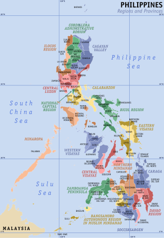
English: Map of the Philippines showing the location of all the regions and provinces.
Notes: The map does not depict cities that are independent of any province. It also does not depict the status of Sabah, the Spratly Islands, and Scarborough Shoal as disputed Philippine territories. |
| 日付 | |
| 原典 | Own work, based on seav's Ph regions and provinces.png and Felipe Aira's File:PhlMapCit.svg |
| 作者 | HueMan1 |
| その他のバージョン |
|

ライセンス
[編集]
この作品の著作権者であるHueMan1は、この作品を以下のライセンスで提供しています。

|
この文書は、フリーソフトウェア財団発行のGNUフリー文書利用許諾書 (GNU Free Documentation License) 1.2またはそれ以降のバージョンの規約に基づき、複製や再配布、改変が許可されます。不可変更部分、表紙、背表紙はありません。このライセンスの複製は、GNUフリー文書利用許諾書という章に含まれています。 |
ファイルの履歴
過去の版のファイルを表示するには、その版の日時をクリックしてください。
| 日付と時刻 | サムネイル | 寸法 | 利用者 | コメント | |
|---|---|---|---|---|---|
| 現在の版 | 2023年7月23日 (日) 05:49 | | 4,200 × 6,105 (2.97メガバイト) | Hariboneagle927 (トーク | 投稿記録) | + Maguindanao division |
| 2023年3月11日 (土) 23:58 |  | 4,200 × 6,105 (2.95メガバイト) | Hariboneagle927 (トーク | 投稿記録) | Bangsamoro SGA in Cotabato (since Lamitan is shown as part of Zamboanga Peninsula in this map) | |
| 2019年12月10日 (火) 15:58 |  | 4,200 × 6,105 (2.94メガバイト) | HueMan1 (トーク | 投稿記録) | Renamed Compostela Valley to Davao de Oro. | |
| 2019年8月9日 (金) 05:09 |  | 4,200 × 6,105 (2.95メガバイト) | HueMan1 (トーク | 投稿記録) | Minor fixes | |
| 2019年7月19日 (金) 12:26 |  | 4,200 × 6,105 (2.95メガバイト) | HueMan1 (トーク | 投稿記録) | Minor fixes | |
| 2019年7月1日 (月) 10:10 |  | 4,200 × 6,105 (2.95メガバイト) | HueMan1 (トーク | 投稿記録) | User created page with UploadWizard |
このファイルは上書きできません。
ファイルの使用状況
以下の 2 ページがこのファイルを使用しています:
グローバルなファイル使用状況
以下に挙げる他のウィキがこの画像を使っています:
- an.wikipedia.org での使用状況
- bcl.wikipedia.org での使用状況
- be-tarask.wikipedia.org での使用状況
- el.wikipedia.org での使用状況
- en.wikipedia.org での使用状況
- Mindanao
- Philippines
- Spratly Islands
- Luzon
- Metro Manila
- Visayas
- Provinces of the Philippines
- Manila
- Barangay
- Regions of the Philippines
- Cities of the Philippines
- Wikipedia:WikiProject Philippine LGUs/Province template
- Municipalities of the Philippines
- Southern Tagalog
- Quezon City
- Lanao del Sur
- Autonomous Region in Muslim Mindanao
- Valenzuela, Metro Manila
- Kalayaan, Palawan
- List of cities and municipalities in the Philippines
- Portal:Philippines
- Administrative divisions of the Philippines
- Template:Administrative divisions of the Philippines
- Portal:Philippines/Topics
- Territories claimed by the Philippines
- Legislative districts of the Philippines
- Talk:Philippines/Archive 7
- Internal Revenue Allotment
- Outline of the Philippines
- Wikipedia talk:Tambayan Philippines/Archive 16
- Barangay captain
- List of primary local government units of the Philippines
- Template:English official language clickable map/testcases
- Partido (historical province)
- Barangay hall
- Bangsamoro
- Barangay elections
- Negros
- User:Dgfddfgs/sandbox
- Autonomous regions of the Philippines
- User:Sanglahi86/sandbox
- Sub-provinces of the Philippines
- User:Jcisawesomeguy/sandbox
- Special Geographic Area
- Caburacanan
- Maguindanao del Norte
このファイルのグローバル使用状況を表示する。