File:Philippine climate map.png
Jump to navigation
Jump to search

Size of this preview: 384 × 599 pixels. Other resolutions: 154 × 240 pixels | 308 × 480 pixels | 492 × 768 pixels | 656 × 1,024 pixels | 2,000 × 3,120 pixels.
Original file (2,000 × 3,120 pixels, file size: 204 KB, MIME type: image/png)
Captions
Captions
Add a one-line explanation of what this file represents
Summary
[edit]
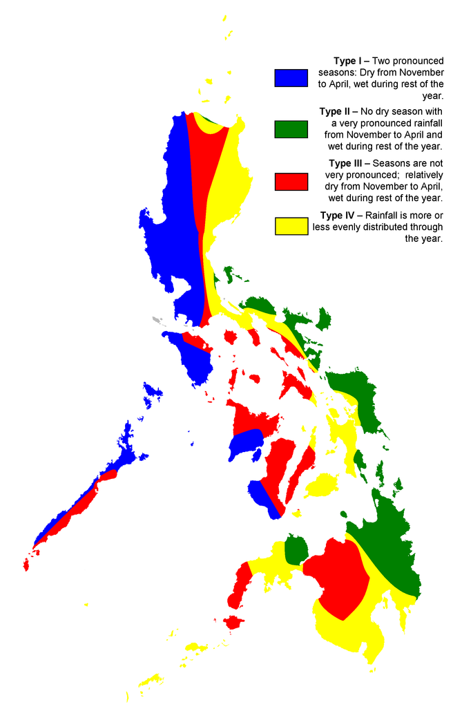
| Description | Map showing the ditribution of rainfall in the Philippines |
| Date | |
| Source | map created by user:Howard the Duck based on map of Philippine meteorological institute PAG-ASA; originally uploaded to English Wikipedia |
| Author | en:User:Howard the Duck |
| Permission (Reusing this file) |
CC-BY-2.5 |
| Other versions | English Wikipedia |
Licensing
[edit]
This file is licensed under the Creative Commons Attribution 2.5 Generic license.
- You are free:
- to share – to copy, distribute and transmit the work
- to remix – to adapt the work
- Under the following conditions:
- attribution – You must give appropriate credit, provide a link to the license, and indicate if changes were made. You may do so in any reasonable manner, but not in any way that suggests the licensor endorses you or your use.

|
This meteorology image could be re-created using vector graphics as an SVG file. This has several advantages; see Commons:Media for cleanup for more information. If an SVG form of this image is available, please upload it and afterwards replace this template with
{{vector version available|new image name}}.
It is recommended to name the SVG file “Philippine climate map.svg”—then the template Vector version available (or Vva) does not need the new image name parameter. |
[[eodjwe9ufnwiojf w9usjfh jkwughjnek d9guhinekrsf ]
File history
Click on a date/time to view the file as it appeared at that time.
| Date/Time | Thumbnail | Dimensions | User | Comment | |
|---|---|---|---|---|---|
| current | 22:10, 4 March 2007 | | 2,000 × 3,120 (204 KB) | Magalhães (talk | contribs) | {{Information |Description= |Source=map created by user:Howard the Duck based on map of Philippine meteorological institute [http://www.pagasa.dost.gov.ph/cab/coronas2.jpg PAG-ASA]; originally uploaded to English Wikipedia |Date=02/23/2007 |Author=[[:en:U |
You cannot overwrite this file.
File usage
The following page uses this file:
Global file usage
The following other wikis use this file:
- Usage on de.wikipedia.org
- Usage on en.wikipedia.org
- Usage on nl.wikipedia.org
- Usage on sq.wikipedia.org
- Usage on uk.wikipedia.org