File:Pia19039 some key places in a survey of the "Pahrump Hills" .jpg

原始文件 (4,067 × 2,184像素,文件大小:2.27 MB,MIME类型:image/jpeg)
说明
说明
摘要
[编辑]
| 描述 |
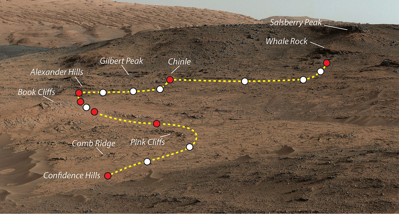
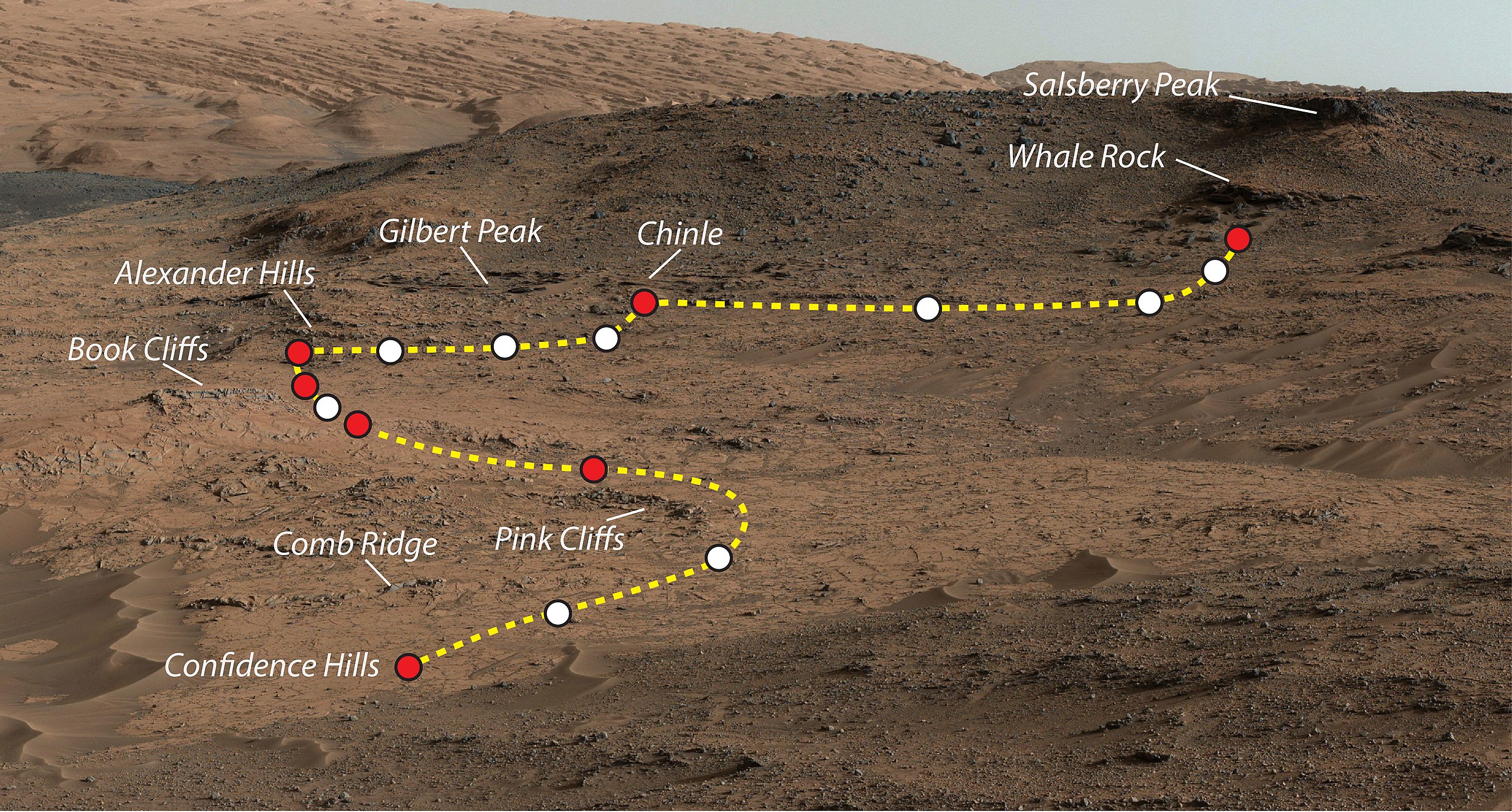
Mars Rover Curiosity's Walkabout at 'Pahrump Hills'. This view shows the path and some key places in a survey of the "Pahrump Hills" outcrop by NASA's Curiosity Mars rover in autumn of 2014. The outcrop is at the base of Mount Sharp within Gale Crater. This view shows the path and some key places in a survey of the "Pahrump Hills" outcrop by NASA's Curiosity Mars rover in autumn of 2014. The outcrop is at the base of Mount Sharp within Gale Crater. The mission's in-place investigation of the layered mountain began at the low edge of the Pahrump Hills outcrop, at the target "Confidence Hills." Curiosity collected a drilled sample of rock powder at that target in September 2014 and delivered portions of the powder into analytical instruments inside the rover. Then the mission began a "walkabout" of the outcrop, similar to the way field geologists on Earth walk across an outcrop to choose the best places on it to examine in detail. The dashed gold line indicates the path the rover drove during the walkabout. Names are shown for a few of the features visited and observed by the rover. Red dots indicate stops at the end of a day's drive. White dots indicate locations of stops made during the drives to collect observations of the Pahrump Hills outcrop. The mission completed the walkabout at the site labeled "Whale Rock", and the team is now examining the observations acquired during the walkabout to decide where to return for more detailed analysis. This view of the outcrop and other portions of Mount Sharp beyond is a mosaic of images taken by the rover's Mast Camera (Mastcam). A larger version of the mosaic is at http://mars.nasa.gov/multimedia/images/?ImageID=6614. NASA's Jet Propulsion Laboratory, a division of the California Institute of Technology, Pasadena, manages the Mars Science Laboratory Project for NASA's Science Mission Directorate, Washington. JPL designed and built the project's Curiosity rover. Malin Space Science Systems, San Diego, built and operates the rover's Mastcam. More information about Curiosity is online at |
| 日期 | |
| 来源 | http://www.nasa.gov/sites/default/files/thumbnails/image/pia19039.jpg |
| 作者 | NASA/JPL-Caltech/MSSS |
| 授权 (二次使用本文件) |
NASA |
许可协议
[编辑]
| 本文件完全由NASA创作,在美国属于公有领域。根据NASA的版权方针,NASA的材料除非另有声明否则不受版权保护。(参见Template:PD-USGov/zh、NASA版权方针页面或JPL图片使用方针。) | ||
 |
警告:
|
文件历史
点击某个日期/时间查看对应时刻的文件。
| 日期/时间 | 缩略图 | 大小 | 用户 | 备注 | |
|---|---|---|---|---|---|
| 当前 | 2014年11月4日 (二) 23:49 | | 4,067 × 2,184(2.27 MB) | Romkur(留言 | 贡献) | {{Information |Description=This view shows the path and some key places in a survey of the "Pahrump Hills" outcrop by NASA's Curiosity Mars rover in autumn of 2014. The outcrop is at the base of Mount Sharp within Gale Crater. Image Credit: NASA/JPL-C... |
您不可以覆盖此文件。
文件用途
没有页面使用本文件。
全域文件用途
以下其他wiki使用此文件:
- en.wikipedia.org上的用途
- pl.wikipedia.org上的用途
- tr.wikipedia.org上的用途
- uk.wikipedia.org上的用途
- zh.wikipedia.org上的用途