File:Pic de Soularac, col du Trou de l'Ours sur la ligne de crête.jpg
Jump to navigation
Jump to search

Size of this preview: 800 × 600 pixels. Other resolutions: 320 × 240 pixels | 640 × 480 pixels | 1,024 × 768 pixels | 1,123 × 842 pixels.
Original file (1,123 × 842 pixels, file size: 456 KB, MIME type: image/jpeg)
Captions
Captions
Add a one-line explanation of what this file represents
Summary
[edit]
| Description |
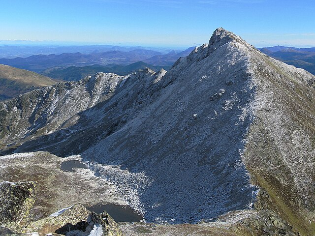
Français : Pic de Soularac depuis le pic de Saint-Barthélémy.
La ligne de crête séparant les deux pics passe par le col du Trou de l'Ours. Étang tort en contre-bas. Image obtenue par assemblage de photographies. |
| Date | |
| Source | Own work |
| Author | Rulhe |
| Camera location | | View this and other nearby images on: OpenStreetMap |
|---|
Licensing
[edit]
I, the copyright holder of this work, hereby publish it under the following license:
| This file is made available under the Creative Commons CC0 1.0 Universal Public Domain Dedication. | |
| The person who associated a work with this deed has dedicated the work to the public domain by waiving all of their rights to the work worldwide under copyright law, including all related and neighboring rights, to the extent allowed by law. You can copy, modify, distribute and perform the work, even for commercial purposes, all without asking permission.
|
File history
Click on a date/time to view the file as it appeared at that time.
| Date/Time | Thumbnail | Dimensions | User | Comment | |
|---|---|---|---|---|---|
| current | 18:01, 10 July 2019 | | 1,123 × 842 (456 KB) | Rulhe (talk | contribs) | User created page with UploadWizard |
You cannot overwrite this file.
File usage on Commons
The following page uses this file:
- File:Col ours v1.jpg (file redirect)
File usage on other wikis
The following other wikis use this file:
- Usage on fr.wikipedia.org