File:Pike & Nau A Chart of the Internal Part of Louisiana 1810 UTA.jpg

Original file (2,439 × 2,759 pixels, file size: 2.03 MB, MIME type: image/jpeg)
Captions
Captions
Summary
[edit]| Title |
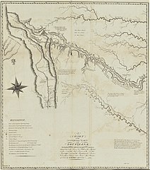
English: A Chart of the Internal Part of Louisiana, Including All the Hitherto Unexplored Countries |
||||||||||||||||||||||||||
| Description |
English: Zebulon Pike and his men were among the first foreigners to visit the Spanish Borderlands. His two maps, as printed by Anthony Nau and possibly Nicholas King, represent an improvement in the geographical knowledge of the area, but they are far from satisfactory as Pike had little scientific training and had worked under terrible conditions. He apparently mistook the Canadian fork of the Arkansas River for the Red River and became lost in the maze of mountains in present central Colorado. His route along the upper Arkansas and a portion of the Rocky Mountains of Colorado as well as the route taken by his Spanish captors (who also confiscated his field map) appear on this map from the 1810 edition of his account. Pike's "Highest Peak" – later renamed for the explorer by his companion Dr. Robinson – is in the upper-left portion of the map. The map was overly simplified, and, by placing the "Yellow Stone River, Branch of the Missouri", "La Platte", and "Sources of the Arkansaw" [sic] in the upper-left corner, it perpetuated a mistaken geographical theory that all the rivers flowing east to the Mississippi and west to the Pacific originated from a small area in the Rockies. |
||||||||||||||||||||||||||
| Date | |||||||||||||||||||||||||||
| Source | UTA Libraries Cartographic Connections: map / text | ||||||||||||||||||||||||||
| Creator |
Anthony Nau After
|
||||||||||||||||||||||||||
| Credit line |
English: UTA Libraries Special Collections |
||||||||||||||||||||||||||
| Geotemporal data | |||||||||||||||||||||||||||
| Map location | United States of America | ||||||||||||||||||||||||||
| Georeferencing | If inappropriate please set warp_status = skip to hide. | ||||||||||||||||||||||||||
| Bibliographic data | |||||||||||||||||||||||||||
| Publication |
An Account of Expeditions to the Sources of the Mississippi, and Through the Western Parts of Louisiana...during the Years 1805, 1806, and 1807. And a Tour through the Interior Parts of New Spain...in the Year 1807 |
||||||||||||||||||||||||||
| Author |
|
||||||||||||||||||||||||||
| Place of publication | Philadelphia | ||||||||||||||||||||||||||
| Publisher |
C. & A. Conrad & Co. |
||||||||||||||||||||||||||
| Archival data | |||||||||||||||||||||||||||
| Collection |
|
||||||||||||||||||||||||||
| Dimensions | height: 44 cm (17.3 in); width: 39 cm (15.3 in) | ||||||||||||||||||||||||||
| Medium | engraving | ||||||||||||||||||||||||||
| artwork-references |
Ehrenberg, Ralph (1987) "Mapping the North American Plains: A Catalog of the Exhibition" in Luebke, Frederick C. , ed. Mapping the North American Plains: Essays in the History of Cartography, Norman: University of Oklahoma Press, pp. 195−197 Ehrenberg, Ralph (2005) "U.S. Army Military Mapping of the American Southwest during the Nineteenth Century" in Reinhartz, Dennis , ed. Mapping and Empire: Soldier-Engineers on the Southwestern Frontier, Austin: University of Texas Press, pp. 80−82 Francaviglia, Richard (2005) Mapping and Imagination in the Great Basin, Reno: University of Nevada Press, pp. 52−53 Wheat Mapping the Trans-Mississippi West, 2, pp. 16- 30, 209, 212, nos. 287, 297−299 Goetzmann, William H. (1959) Army Exploration in the American West, New Haven: Yale University Press, pp. 36−39 Cohen, Paul E. , ed. (2002) Mapping the West: America’s Westward Movement 1524-1890, New York City: Rizzoli, pp. 97−99 |
||||||||||||||||||||||||||

Licensing
[edit]

|
This file was provided to Wikimedia Commons by the University of Texas at Arlington Libraries as part of a cooperation project. The University of Texas at Arlington Libraries is part of the University of Texas at Arlington, a public research university located in Arlington, Texas.
|
|
The author died in 1813, so this work is in the public domain in its country of origin and other countries and areas where the copyright term is the author's life plus 100 years or fewer. This work is in the public domain in the United States because it was published (or registered with the U.S. Copyright Office) before January 1, 1929. | |
| This file has been identified as being free of known restrictions under copyright law, including all related and neighboring rights. | |
File history
Click on a date/time to view the file as it appeared at that time.
| Date/Time | Thumbnail | Dimensions | User | Comment | |
|---|---|---|---|---|---|
| current | 00:51, 23 February 2022 | | 2,439 × 2,759 (2.03 MB) | Michael Barera (talk | contribs) | == {{int:filedesc}} == {{Map |title = {{en|'''''A Chart of the Internal Part of Louisiana, Including All the Hitherto Unexplored Countries'''''}} |description = {{en|Zebulon Pike and his men were among the first foreigners to visit the Spanish Borderlands. His two maps, as printed by Anthony Nau and possibly Nicholas King, represent an improvement in the geographical knowledge of the area, but they are far from satisfactory as Pike had little scientific training and had wo... |
You cannot overwrite this file.
File usage on Commons
The following 2 pages use this file: