File:Piton Fournaise eruptions animated-fr.gif
跳至導覽
跳至搜尋

預覽大小:514 × 600 像素。 其他解析度:206 × 240 像素 | 411 × 480 像素 | 720 × 840 像素。
原始檔案 (720 × 840 像素,檔案大小:678 KB,MIME 類型:image/gif、循環、19 畫格、30秒)
說明
說明
添加單行說明來描述出檔案所代表的內容
摘要[編輯]
| 描述 |
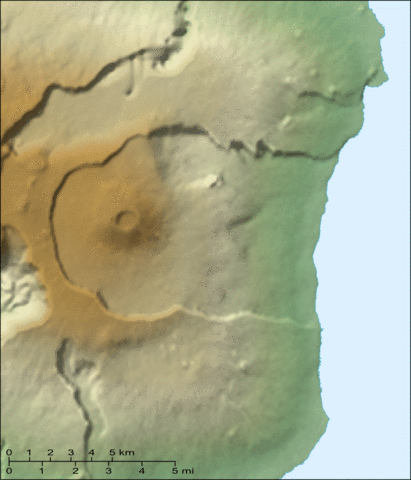
English: Animated map of the recent eruptions (1972 to 2000) of the Piton de la Fournaise shield volcano on the Réunion island.
Français : Carte animée des éruptions récentes (1972 à 2000) du volcan du Piton de la Fournaise sur l'île de la Réunion. |
||
| 日期 | |||
| 來源 |
Own work ; Topographic map : NASA Shuttle Radar Topography Mission (SRTM3 v.2) (public domain) edited with 3DEM from Visualization Software LLC ; Animation created with The GIMP ; References used : Maps from the Institut de Physique du Globe de Paris. |
||
| 作者 | Eric Gaba (Sting - fr:Sting) | ||
| 授權許可 (重用此檔案) |
|
||
| 其他版本 |
|


授權條款[編輯]
我,本作品的著作權持有者,決定用以下授權條款發佈本作品:

|
已授權您依據自由軟體基金會發行的無固定段落、封面文字和封底文字GNU自由文件授權條款1.2版或任意後續版本,對本檔進行複製、傳播和/或修改。該協議的副本列在GNU自由文件授權條款中。 |
| 此檔案採用創用CC 姓名標示-相同方式分享 3.0 未在地化版本授權條款。 | ||
| ||
| 已新增授權條款標題至此檔案,作為GFDL授權更新的一部份。 |
您可以選擇您需要的授權條款。
檔案歷史
點選日期/時間以檢視該時間的檔案版本。
| 日期/時間 | 縮圖 | 尺寸 | 使用者 | 備註 | |
|---|---|---|---|---|---|
| 目前 | 2007年6月13日 (三) 19:10 | | 720 × 840(678 KB) | Sting(留言 | 貢獻) | Forgotten scale |
| 2007年6月13日 (三) 13:56 |  | 720 × 840(676 KB) | Sting(留言 | 貢獻) | Lighter visual version (less crater names) | |
| 2007年6月12日 (二) 21:03 |  | 720 × 840(687 KB) | Sting(留言 | 貢獻) | {{Information |Description=Animated map of the recent eruptions (1972 to 2000) of the ''Piton de la Fournaise'' shield volcano on the Réunion island. |Source=Own work ;<br/>Topographic map : [http://www2.jpl |
無法覆蓋此檔案。
檔案用途
下列28個頁面有用到此檔案:
- Wikimedia Conference Japan 2009/Commons写真展
- User:Miya/Introduction
- User:Sting/Gallery: Regional maps
- User:Sting/Profile
- Commons:Bu proje sayfasının diğer dil sürümleri
- Commons:Conhece os nossos ilustradores
- Commons:Conoce a nuestros ilustradores
- Commons:Descobreix els nostres il.lustradors
- Commons:Descobrètz nòstres illustrators
- Commons:Découvrez nos illustrateurs
- Commons:Meet our illustrators
- Commons:Meet our illustrators/People
- Commons:Poznaj naszych grafików
- Commons:Scopri i nostri illustratori
- Commons:Scummigghia ê nostri llustratura
- Commons:Unsere Illustratoren stellen sich vor
- Commons:Unseri Illustratore stelle sich vor
- Commons:Upoznajte naše ilustratore
- Commons:Çizerlerimizle tanışın
- Commons:Запознајте ги нашите илустратори
- Commons:Знайомтесь з нашими ілюстраторами
- Commons:Знакомьтесь с нашими иллюстраторами
- Commons:قابل رسامينا
- Commons:私達のイラストレータをご紹介します
- Commons:结识我们的插图师
- Commons:우리들의 삽화가를 만나보세요
- File:Piton Fournaise 1972-2000 eruptions-fr.svg
- File:Piton Fournaise topo map-fr.svg
全域檔案使用狀況
以下其他 wiki 使用了這個檔案:
- ar.wikipedia.org 的使用狀況
- de.wikivoyage.org 的使用狀況
- en.wikipedia.org 的使用狀況
- fr.wikipedia.org 的使用狀況
- he.wikipedia.org 的使用狀況
- pl.wikipedia.org 的使用狀況
- sv.wikipedia.org 的使用狀況
- zh.wikipedia.org 的使用狀況