File:Pittsburg, North Carolina location map.jpg
Jump to navigation
Jump to search

Size of this preview: 800 × 403 pixels. Other resolutions: 320 × 161 pixels | 640 × 322 pixels | 1,024 × 515 pixels | 1,280 × 644 pixels | 2,674 × 1,346 pixels.
Original file (2,674 × 1,346 pixels, file size: 276 KB, MIME type: image/jpeg)
Captions
Captions
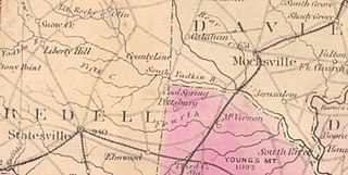
Location of Pittsburg in Rowan County, North Carolina in 1882
Summary
[edit]
| Description |
English: Portion of North Carolina Map
Color print, mounted on linen. This map was prepared by Washington Caruthers Kerr (1827-1885), state geologist, with the assistance of William Cain (1847-1930), later professor of mathematics and engineering at the University of North Carolina, for the North Carolina State Board of Agriculture. The map was the result of extensive gathering of information by Kerr for more than fifteen years prior to its publication and embodies his first hand observations made while traveling to every part of the state in his work as state geologist. Kerr based the map on surveys and charts of the U.S. Geological Survey and also incorporated information from Post Route maps and railroad maps and surveys so that this map contains more detailed information about cities and towns, roads, and railroads than previous maps of the state. Arnold Guyot, Kerr's professor of Geology and Physical Geography at Princeton, also contributed information about the mountain region of the state. Counties are delineated and named, and the map provides correct boundaries for some of the counties for the first time. Rivers and streams are identified and other topographical features are shown. An alphabetical list of the towns in the state having a population of 500 people or more, notes containing statistical information about the state, and an alphabetical list of the railroads in North Carolina appear in the lower left of the map. |
| Date | |
| Source | Cut and past from UNC Digital Map library |
| Author |
Map of North Carolina, by W. C. Kerr, State Geologist Created in 1882 |
Licensing
[edit]
This work is in the public domain in the United States because it was published (or registered with the U.S. Copyright Office) before January 1, 1929.
Public domain works must be out of copyright in both the United States and in the source country of the work in order to be hosted on the Commons. If the work is not a U.S. work, the file must have an additional copyright tag indicating the copyright status in the source country.
Note: This tag should not be used for sound recordings. |
File history
Click on a date/time to view the file as it appeared at that time.
| Date/Time | Thumbnail | Dimensions | User | Comment | |
|---|---|---|---|---|---|
| current | 17:58, 25 March 2022 | | 2,674 × 1,346 (276 KB) | G. Moore (talk | contribs) | Uploaded a work by Map of North Carolina, by W. C. Kerr, State Geologist Created in 1882 from Cut and past from UNC Digital Map library with UploadWizard |
You cannot overwrite this file.
File usage on Commons
There are no pages that use this file.
File usage on other wikis
The following other wikis use this file:
- Usage on en.wikipedia.org