File:Plan-Renner-Koenigsfelden-1778.jpg

Original file (2,020 × 889 pixels, file size: 534 KB, MIME type: image/jpeg)
Captions
Captions
Summary[edit]
| DescriptionPlan-Renner-Koenigsfelden-1778.jpg |
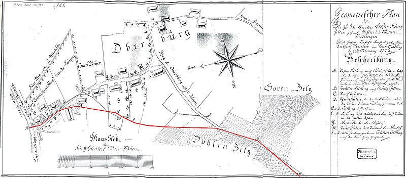
Deutsch: Windisch-Oberburg, Wasserleitungsplan aus dem Jahr 1778 von A. Renner
Röm. Wasserleitung (rot), Dohlen und Brunnenzuleitungen nach Königsfelden Es handelt sich um die älteste bekannte planerische Darstellung der wasserführenden römischen / mittelalterlichen Wasserleitung von Vindonissa, die hier zusätzlich rot markiert ist Überschrift: "Geomterischer Plan über die zu Ihr Gnaden Closter Königsfelden gehenden Dohlen und Brunnen-Leitungen auf hohen Befehl verfertigt, von Anthonj Renner im Baad Habsburg den 25. February 1778". |
| Date | |
| Source |
Staatsarchiv Aarau, Band AA/451 Veröffentlicht: Jürgen Trumm: Ausgrabungen in Vindonissa im Jahr 2011. In: Jahresbericht Gesellschaft Pro Vindonissa. 2011, S. 85, Abb. 6 |
| Author | Anthonj Renner |
Licensing[edit]
| Public domainPublic domainfalsefalse |
|
This work is in the public domain in its country of origin and other countries and areas where the copyright term is the author's life plus 70 years or fewer. This work is in the public domain in the United States because it was published (or registered with the U.S. Copyright Office) before January 1, 1929. | |
| This file has been identified as being free of known restrictions under copyright law, including all related and neighboring rights. | |
https://creativecommons.org/publicdomain/mark/1.0/PDMCreative Commons Public Domain Mark 1.0falsefalse
File history
Click on a date/time to view the file as it appeared at that time.
| Date/Time | Thumbnail | Dimensions | User | Comment | |
|---|---|---|---|---|---|
| current | 17:13, 15 June 2019 |  | 2,020 × 889 (534 KB) | Didia (talk | contribs) | User created page with UploadWizard |
You cannot overwrite this file.
File usage on Commons
There are no pages that use this file.
File usage on other wikis
The following other wikis use this file:
- Usage on de.wikipedia.org
Metadata
This file contains additional information such as Exif metadata which may have been added by the digital camera, scanner, or software program used to create or digitize it. If the file has been modified from its original state, some details such as the timestamp may not fully reflect those of the original file. The timestamp is only as accurate as the clock in the camera, and it may be completely wrong.
| Camera manufacturer | XEROX |
|---|---|
| Camera model | WIDE FORMAT |
| Width | 2,020 px |
| Height | 889 px |
| Bits per component |
|
| Compression scheme | Uncompressed |
| Pixel composition | RGB |
| Orientation | Normal |
| Number of components | 3 |
| Horizontal resolution | 300 dpi |
| Vertical resolution | 300 dpi |
| Data arrangement | chunky format |
| Software used | Adobe Photoshop CS4 Windows |
| File change date and time | 10:53, 27 June 2012 |
| Color space | Uncalibrated |
| Image width | 2,020 px |
| Image height | 889 px |
| Date and time of digitizing | 12:55, 1 September 2011 |
| Date metadata was last modified | 12:53, 27 June 2012 |
| Unique ID of original document | xmp.did:C91A7F4323D5E01181AFA7A9631A0844 |