File:Plan Paris Tramway ligne 3b-2019.svg
Jump to navigation
Jump to search

Size of this PNG preview of this SVG file: 800 × 224 pixels. Other resolutions: 320 × 90 pixels | 640 × 179 pixels | 1,024 × 287 pixels | 1,280 × 359 pixels | 2,560 × 718 pixels | 2,169 × 608 pixels.
Original file (SVG file, nominally 2,169 × 608 pixels, file size: 102 KB)
Captions
Captions
Add a one-line explanation of what this file represents
Summary[edit]
| Description |
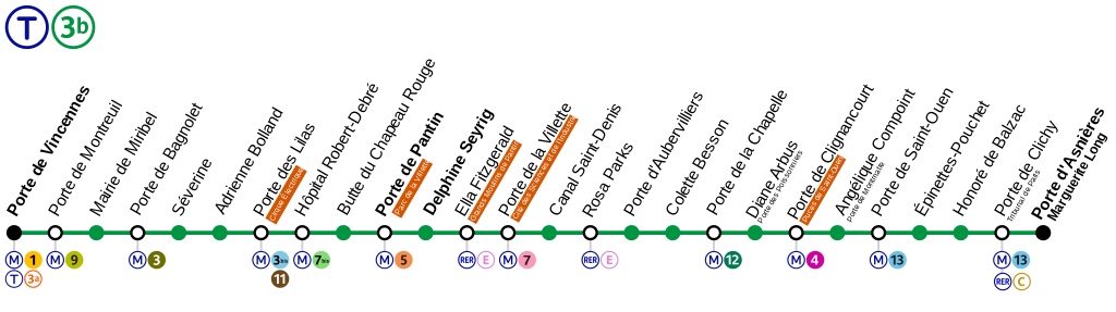
Français : Plan de la ligne 9 du tramway de Paris en 2019. |
| Date | |
| Source | Own work |
| Author | Chabe01 |
Licensing[edit]
I, the copyright holder of this work, hereby publish it under the following license:
This file is licensed under the Creative Commons Attribution-Share Alike 4.0 International license.
- You are free:
- to share – to copy, distribute and transmit the work
- to remix – to adapt the work
- Under the following conditions:
- attribution – You must give appropriate credit, provide a link to the license, and indicate if changes were made. You may do so in any reasonable manner, but not in any way that suggests the licensor endorses you or your use.
- share alike – If you remix, transform, or build upon the material, you must distribute your contributions under the same or compatible license as the original.
File history
Click on a date/time to view the file as it appeared at that time.
| Date/Time | Thumbnail | Dimensions | User | Comment | |
|---|---|---|---|---|---|
| current | 01:11, 20 December 2019 | 2,169 × 608 (102 KB) | AlexBurn44 (talk | contribs) | ++ | |
| 10:14, 21 November 2019 | 2,195 × 571 (98 KB) | Chabe01 (talk | contribs) | Réalignement des noms des stations et améliorations graphiques | ||
| 10:32, 23 October 2019 | 2,206 × 608 (101 KB) | AlexBurn44 (talk | contribs) | ++ | ||
| 10:20, 23 October 2019 | 2,206 × 608 (101 KB) | AlexBurn44 (talk | contribs) | ++ | ||
| 10:19, 23 October 2019 | 2,169 × 608 (103 KB) | AlexBurn44 (talk | contribs) | Ajout de sous titres | ||
| 03:24, 25 November 2018 | 2,206 × 608 (96 KB) | Chabe01 (talk | contribs) | Amélioration, notamment les noms des stations. | ||
| 20:48, 18 November 2018 | 2,169 × 608 (97 KB) | AlexBurn44 (talk | contribs) | Ajout de sous- titres | ||
| 21:25, 12 October 2018 | 2,169 × 608 (95 KB) | AlexBurn44 (talk | contribs) | Ajout de sous titres a pte des lilas et pte clignancourt | ||
| 15:57, 21 February 2018 | 2,169 × 608 (95 KB) | Chabe01 (talk | contribs) | User created page with UploadWizard |
You cannot overwrite this file.
File usage on Commons
The following 25 pages use this file:
- User:Chumwa/OgreBot/Potential transport maps/2018 February 19-28
- User:Chumwa/OgreBot/Potential transport maps/2018 November 11-20
- User:Chumwa/OgreBot/Potential transport maps/2018 November 21-30
- User:Chumwa/OgreBot/Potential transport maps/2018 October 11-20
- User:Chumwa/OgreBot/Potential transport maps/2019 December 11-20
- User:Chumwa/OgreBot/Potential transport maps/2019 November 21-30
- User:Chumwa/OgreBot/Potential transport maps/2019 October 21-31
- User:Chumwa/OgreBot/Public transport information/2018 February 19-28
- User:Chumwa/OgreBot/Public transport information/2018 November 11-20
- User:Chumwa/OgreBot/Public transport information/2018 November 21-30
- User:Chumwa/OgreBot/Public transport information/2018 October 11-20
- User:Chumwa/OgreBot/Public transport information/2019 December 11-20
- User:Chumwa/OgreBot/Public transport information/2019 November 21-30
- User:Chumwa/OgreBot/Public transport information/2019 October 21-31
- User:Chumwa/OgreBot/Transport Maps/2018 February 19-28
- User:Chumwa/OgreBot/Transport Maps/2018 November 11-20
- User:Chumwa/OgreBot/Transport Maps/2018 November 21-30
- User:Chumwa/OgreBot/Transport Maps/2018 October 11-20
- User:Chumwa/OgreBot/Transport Maps/2019 December 11-20
- User:Chumwa/OgreBot/Transport Maps/2019 November 21-30
- User:Chumwa/OgreBot/Transport Maps/2019 October 21-31
- User:Chumwa/OgreBot/Travel and communication maps/2018 February 19-28
- User:Chumwa/OgreBot/Travel and communication maps/2018 November 11-20
- User:Chumwa/OgreBot/Travel and communication maps/2018 November 21-30
- User:Chumwa/OgreBot/Travel and communication maps/2018 October 11-20
File usage on other wikis
The following other wikis use this file:
- Usage on cs.wikipedia.org
- Usage on eo.wikipedia.org