File:Plan SPb 1700 expl.png
Plan_SPb_1700_expl.png (696 × 486 pixels, file size: 40 KB, MIME type: image/png)
Captions
Captions
Summary
[edit]
| Description |
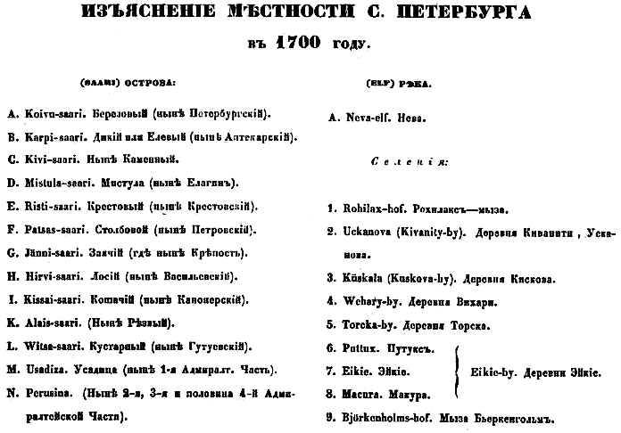
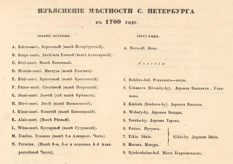
English: An explication to the map of Saint-Petersburg (1700), historical reconstruction of 1853 |
| Date | |
| Source | http://www.aroundspb.ru/maps/spb1700_1849/13.jpg |
| Author | Планы С.Петербурга в 1700, 1705, 1725, 1738, 1756, 1777, 1799, 1840, 1849 годах, с приложением планов 13 частей столицы 1853 года. Составлен Н.Цыловым |
Licensing
[edit]
| I, the copyright holder of this work, release this work into the public domain. This applies worldwide. In some countries this may not be legally possible; if so: I grant anyone the right to use this work for any purpose, without any conditions, unless such conditions are required by law. |
|
This work is in the public domain in its country of origin and other countries and areas where the copyright term is the author's life plus 70 years or fewer.
| |
| This file has been identified as being free of known restrictions under copyright law, including all related and neighboring rights. | |
File history
Click on a date/time to view the file as it appeared at that time.
| Date/Time | Thumbnail | Dimensions | User | Comment | |
|---|---|---|---|---|---|
| current | 18:05, 7 November 2010 | | 696 × 486 (40 KB) | Cherurbino (talk | contribs) | {{Information |Description={{en|1=An explication to the map of Saint-Petersburg (1700), historical reconstruction of 1853}} |Source=http://www.aroundspb.ru/maps/spb1700_1849/13.jpg |Author=Планы С.Петербурга в 1700, 1705, 1725, 1738, 1756 |
You cannot overwrite this file.
File usage on Commons
There are no pages that use this file.
File usage on other wikis
The following other wikis use this file:
- Usage on ru.wikipedia.org