File:Plan descriptif de la bataille de Toulon 1744.jpg

Original file (1,515 × 1,000 pixels, file size: 479 KB, MIME type: image/jpeg)
Captions
Captions
Summary
[edit]| Author |
|
|||||||||||||||||||||||||
| Title |
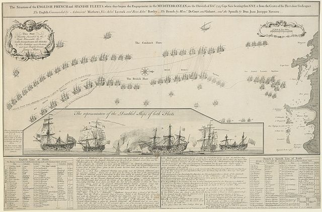
The Situation of the ENGLISH, FRENCH and SPANISH FLEETS, when they begun the Engagement in the MEDITERRANEAN, on the Eleventh of Feb.y 174¾. Cape Sicie bearing then N.N.E. from the Center of the Fleet about Ten Leagues. The English Commanded by Admiral Mathews, Vice Adm.l Lestock and Rear Adm.l Rowley. The French by Mons.r DeCourt and Gabaret, and the Spanish by Don Juan Joseppo Navarro. This Plate is Humbly Inscrib'd to the Right Honourable the Lords Commissioners of ye Admiralty / by their Lordships most Obedient / and most Dutiful Servant, / James Main. |
|||||||||||||||||||||||||
| Description |
English: English engraving depicting the battle at Toulon in 1744 with a summary of the action and a description of the most damaged vessels.
William Henry Toms (active 1723-61) (engraver and publisher) [bottom left:] W.H. Toms Sculp.; [bottom, right of centre, below text:] Publish’d Feb: 29 1744-5 According to Act of Parliament, and sold by W.H. Toms Engraver in Union Court near Hatton Garden Holborn, & by the Printsellers of London & Westminster, Price Plain 2.s & 4.s Colour’d James Main (active 1745) (draughtsman) [bottom left:] James Main Delin Lords Commissioners of the Admiralty (dedicatee) Main listed ships: A. HMS Marlborough. B. Prince (Princess). C. Ann Galley fire ship. E. Real Felipe. F. Constante. G. Poder.Français : Gravure anglaise présentant la bataille devant Toulon en 1744 avec un résumé de l'action et l'état des vaisseaux les plus abimés. Español: Inglés grabado que representa la batalla de Tolón en 1744 con un resumen de la acción y una descripción de los barcos más dañados. |
|||||||||||||||||||||||||
| Depicted place | Toulon, Provence-Alpes-Côte d'Azur (42°46'39"N 05°41'27"E) | |||||||||||||||||||||||||
| Date | 1745 | |||||||||||||||||||||||||
| Medium | Etching and engraving | |||||||||||||||||||||||||
| Dimensions | Scale: 1:164,200 approx. Scale bar: 5 miles [49 mm =]. 47.4 x 71.8 cm (image); 47.9 x 72.8 cm (platemark); 49.4 x 73.8 cm (sheet); 35.2 x 71.8 cm (image of map); 31.4 x 71.3 cm (neatline of map) | |||||||||||||||||||||||||
| Source/Photographer |
Bibliothèque nationale de France |
|||||||||||||||||||||||||
| Other versions |
|
|||||||||||||||||||||||||

Licensing
[edit]
|
This is a faithful photographic reproduction of a two-dimensional, public domain work of art. The work of art itself is in the public domain for the following reason:
The official position taken by the Wikimedia Foundation is that "faithful reproductions of two-dimensional public domain works of art are public domain".
This photographic reproduction is therefore also considered to be in the public domain in the United States. In other jurisdictions, re-use of this content may be restricted; see Reuse of PD-Art photographs for details. | ||||
File history
Click on a date/time to view the file as it appeared at that time.
| Date/Time | Thumbnail | Dimensions | User | Comment | |
|---|---|---|---|---|---|
| current | 17:03, 27 February 2016 | | 1,515 × 1,000 (479 KB) | AYE R (talk | contribs) | Larger version from http://gallica.bnf.fr/ark:/12148/btv1b6944935h/ |
| 12:19, 17 July 2011 |  | 1,106 × 722 (380 KB) | AYE R (talk | contribs) |
You cannot overwrite this file.
File usage on Commons
The following 3 pages use this file:
File usage on other wikis
The following other wikis use this file:
- Usage on ca.wikipedia.org
- Usage on fr.wikipedia.org
- Usage on it.wikipedia.org
- Usage on ro.wikipedia.org