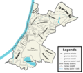
File:Podział administracyjny Grudziądza.png
From Wikimedia Commons, the free media repository
Jump to navigation
Jump to search

Size of this preview: 676 × 600 pixels. Other resolutions: 271 × 240 pixels | 541 × 480 pixels | 866 × 768 pixels | 1,154 × 1,024 pixels | 2,040 × 1,810 pixels.
Original file (2,040 × 1,810 pixels, file size: 669 KB, MIME type: image/png)
File information
Structured data
Captions
Captions
Add a one-line explanation of what this file represents
Podział administracyjny Grudziądza
Summary[edit]
| DescriptionPodział administracyjny Grudziądza.png |
Polski: Podział administracyjny Grudziądza
English: Administrative division of Grudziądz |
| Date | |
| Source |
Map is based on Google Maps, File:Grudziądz_location_map.png, little on this document and little on File:Mapa osiedli Grudziadz.PNG. |
| Author | JakaśKreatywnaNazwa123 |
| Permission (Reusing this file) |
I, the copyright holder of this work, hereby publish it under the following license: This file is licensed under the Creative Commons Attribution-Share Alike 4.0 International license.
|
| Other versions |
|
File history
Click on a date/time to view the file as it appeared at that time.
| Date/Time | Thumbnail | Dimensions | User | Comment | |
|---|---|---|---|---|---|
| current | 21:05, 25 November 2022 |  | 2,040 × 1,810 (669 KB) | JakaśKreatywnaNazwa (talk | contribs) | Granica osiedli Tarpna |
| 15:12, 13 October 2022 |  | 2,040 × 1,810 (672 KB) | JakaśKreatywnaNazwa (talk | contribs) | Granica Owczarek + PSE | |
| 18:36, 10 September 2022 |  | 2,041 × 1,811 (677 KB) | JakaśKreatywnaNazwa (talk | contribs) | Lotnisko Przemysłowe + poprawa napisów i granic | |
| 14:28, 21 August 2022 |  | 2,050 × 1,819 (667 KB) | JakaśKreatywnaNazwa (talk | contribs) | Nazwy dzielnic i granice + jeziora i cieki wodne | |
| 19:33, 19 August 2022 |  | 2,000 × 1,805 (599 KB) | JakaśKreatywnaNazwa (talk | contribs) | Drobna poprawka v2 | |
| 17:49, 19 August 2022 |  | 2,000 × 1,805 (596 KB) | JakaśKreatywnaNazwa (talk | contribs) | Drobna poprawka | |
| 17:27, 19 August 2022 |  | 2,044 × 1,820 (550 KB) | JakaśKreatywnaNazwa (talk | contribs) | Odświeżona wersja mapy wraz z osiedlami i poprawionymi błędami | |
| 15:14, 29 April 2022 |  | 1,896 × 1,740 (502 KB) | JakaśKreatywnaNazwa (talk | contribs) | Korekta | |
| 14:36, 29 April 2022 |  | 1,856 × 1,736 (504 KB) | JakaśKreatywnaNazwa (talk | contribs) | Uploaded own work with UploadWizard |
You cannot overwrite this file.
File usage on Commons
The following page uses this file:
File usage on other wikis
The following other wikis use this file:
- Usage on pl.wikipedia.org
Metadata
This file contains additional information such as Exif metadata which may have been added by the digital camera, scanner, or software program used to create or digitize it. If the file has been modified from its original state, some details such as the timestamp may not fully reflect those of the original file. The timestamp is only as accurate as the clock in the camera, and it may be completely wrong.
| Horizontal resolution | 37.79 dpc |
|---|---|
| Vertical resolution | 37.79 dpc |
| File change date and time | 21:04, 25 November 2022 |
Hidden categories:

