File:Pohorelice 1936.png
Jump to navigation
Jump to search

Size of this preview: 625 × 599 pixels. Other resolutions: 250 × 240 pixels | 501 × 480 pixels | 825 × 791 pixels.
Original file (825 × 791 pixels, file size: 999 KB, MIME type: image/png)
Captions
Captions
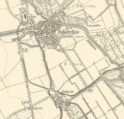
City of Pohorelice (Czech Republic, Brno-venkov) on a map from 1936
Summary[edit]
| Description |
English: III. military mapping. In: Virtual map collection Chartae-Antiquae.cz [online]. Zdiby: Research Institute of Geodesy, Topography and Cartography, v.v.i. [2021-03-03]. Owner: National Archive
Čeština: III. vojenské mapování. In: Virtualní mapová sbírka Chartae-Antiquae.cz [online]. Zdiby: Výzkumný ústav geodetický, topografický a kartografický, v.v.i. [cit. 2021-03-03]. Vlastník: Národní archív. Měřítko: 1:25000 |
| Date | |
| Source | http://chartae-antiquae.cz/cs/maps/43143 |
| Author | III. vojenské mapování |
Licensing[edit]
|
This work is in the public domain in its country of origin and other countries and areas where the copyright term is the author's life plus 70 years or fewer. This work is in the public domain in the United States because it was published (or registered with the U.S. Copyright Office) before January 1, 1929. | |
| This file has been identified as being free of known restrictions under copyright law, including all related and neighboring rights. | |
File history
Click on a date/time to view the file as it appeared at that time.
| Date/Time | Thumbnail | Dimensions | User | Comment | |
|---|---|---|---|---|---|
| current | 09:27, 3 March 2021 | | 825 × 791 (999 KB) | Broukalka (talk | contribs) | Uploaded a work by III. vojenské mapování from http://chartae-antiquae.cz/cs/maps/43143 with UploadWizard |
You cannot overwrite this file.
File usage on Commons
There are no pages that use this file.
File usage on other wikis
The following other wikis use this file:
- Usage on cs.wikipedia.org