File:Poland administrative districts (1998).svg
Jump to navigation
Jump to search

Size of this PNG preview of this SVG file: 644 × 600 pixels. Other resolutions: 258 × 240 pixels | 516 × 480 pixels | 825 × 768 pixels | 1,100 × 1,024 pixels | 2,200 × 2,048 pixels | 1,000 × 931 pixels.
Original file (SVG file, nominally 1,000 × 931 pixels, file size: 2.5 MB)
Captions
Captions
Add a one-line explanation of what this file represents
Summary[edit]
.svg&action=edit§ion=1)
| Description |
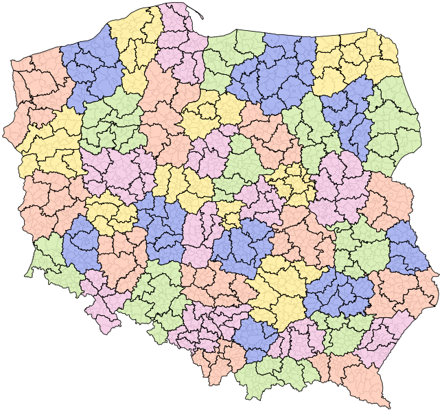
English: Map of Polish administrative districts as of 31 December 1998.
Legend: gray lines – commune borders, black borders – district borders, coloured areas – voivodeship borders. Polski: Mapa rejonów według stanu z 31 grudnia 1998 roku. Legenda: szare linie – granice gmin, czarne linie – granice rejonów, kolorowe obszary – województwa. |
| Date | |
| Source | Rozporządzenie Ministra - Szefa Urzędu Rady Ministrów z dnia 9 czerwca 1995 r. w sprawie określenia siedzib i terytorialnego zasięgu działania urzędów rejonowych (Dz.U. 1995 nr 66 poz. 341, z późn. zm.). |
| Author | TexLacerta |
Licensing[edit]
.svg&action=edit§ion=2)
I, the copyright holder of this work, hereby publish it under the following license:
This file is licensed under the Creative Commons Attribution 4.0 International license.
- You are free:
- to share – to copy, distribute and transmit the work
- to remix – to adapt the work
- Under the following conditions:
- attribution – You must give appropriate credit, provide a link to the license, and indicate if changes were made. You may do so in any reasonable manner, but not in any way that suggests the licensor endorses you or your use.
File history
Click on a date/time to view the file as it appeared at that time.
| Date/Time | Thumbnail | Dimensions | User | Comment | |
|---|---|---|---|---|---|
| current | 18:15, 17 January 2024 | | 1,000 × 931 (2.5 MB) | TexLacerta (talk | contribs) | == {{int:filedesc}} == {{Information |description={{en|1=Map of Polish administrative districts as of 31 December 1998.<br/>Legend: gray lines – commune borders, black borders – district borders, coloured areas – voivodeship borders.}} {{pl|1=Mapa rejonów według stanu z 31 grudnia 1998 roku.<br/>Legenda: szare linie – granice gmin, czarne linie – granice rejonów, kolorowe obszary – województwa.}} |date=2024-01-17 |source=[https://isap.sejm.gov.pl/isap.nsf/DocDetails.xsp?id=WDU19950660341 Rozp... |
You cannot overwrite this file.
File usage on Commons
There are no pages that use this file.
File usage on other wikis
The following other wikis use this file:
- Usage on pl.wikipedia.org
.svg&oldid=843016584)