File:Polish-Lithuania map (1450-1600).svg
跳至導覽
跳至搜尋

此 SVG 檔案的 PNG 預覽的大小:458 × 599 像素。 其他解析度:183 × 240 像素 | 367 × 480 像素 | 587 × 768 像素 | 782 × 1,024 像素 | 1,565 × 2,048 像素 | 726 × 950 像素。
原始檔案 (SVG 檔案,表面大小:726 × 950 像素,檔案大小:72 KB)
說明
說明
添加單行說明來描述出檔案所代表的內容
摘要
[編輯].svg&action=edit§ion=1)
| 描述 |
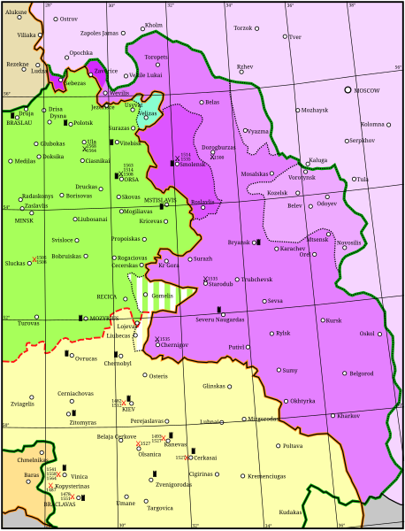
English: Map showing the conflicts and territory of the union (later commonwealth) of Poland-Lithuania.
National border
Administrative or temporal division
The Grand Duchy of Lithuania in 1450
Livonia
Other rule
Russia before 1494
Significant battles fought by Poland-Lithuania. Red: against the Tartars; Black: against Russia. Year given in small type.
Significant fortress |
| 日期 | |
| 來源 | 自己的作品 |
| 作者 | Grandiose, adapted considerably from: (2001) Lietuvos istorijos atlasas, Vilnius: Vaga, pp. 16-17 國際標準書號 5-415-01577-9 |
| File | Type | Details |
|---|---|---|
| File:Polish-Lithuania map (1450-1600).svg | Large SVG | Map showing conflicts and territorial changes on the Polish-Lithuanian—Russian border, 1450–1600 |
| File:Duchy of Prussia.svg | Small SVG | Map of the Duchy of Prussia |
| File:Livonian war map (1558-1560).svg | Small SVG | Map showing campaigns in Livonia, 1558–1560. |
| File:Map of Poland and Lithuania after the Union of Lublin (1569).svg | Large SVG | Map of the w:Polish-Lithuanian Commonwealth after the Union of Lublin in 1569. |
| File:Livonian war map (1570-1577).svg | Small SVG | Map showing areas of Russian and Polish-Lithuanian forces, 1570–1577. |
| File:Campaigns of Stefan Batory.svg | Small SVG | Map of the campaign of Stefan Batory in Livonia (1575–1580). |
| File:Map of Poland and Lithuania in 1600.svg | Small SVG | Map of Livonia in 1600 |
| See also: User:Halibutt/maps, by Halibutt (留言 · 貢獻). | ||
.svg)
.svg)
.svg)
授權條款
[編輯].svg&action=edit§ion=2)
我,本作品的著作權持有者,決定用以下授權條款發佈本作品:
此檔案採用創用CC 姓名標示-相同方式分享 3.0 未在地化版本授權條款。
- 您可以自由:
- 分享 – 複製、發佈和傳播本作品
- 重新修改 – 創作演繹作品
- 惟需遵照下列條件:
- 姓名標示 – 您必須指名出正確的製作者,和提供授權條款的連結,以及表示是否有對內容上做出變更。您可以用任何合理的方式來行動,但不得以任何方式表明授權條款是對您許可或是由您所使用。
- 相同方式分享 – 如果您利用本素材進行再混合、轉換或創作,您必須基於如同原先的相同或兼容的條款,來分布您的貢獻成品。
檔案歷史
點選日期/時間以檢視該時間的檔案版本。
| 日期/時間 | 縮圖 | 尺寸 | 使用者 | 備註 | |
|---|---|---|---|---|---|
| 目前 | 2011年4月24日 (日) 18:02 | | 726 × 950(72 KB) | Grandiose(留言 | 貢獻) | Optimise |
| 2011年4月18日 (一) 18:42 |  | 726 × 950(1.5 MB) | Grandiose(留言 | 貢獻) | Longitude and latitude lines. | |
| 2011年4月18日 (一) 14:27 |  | 726 × 950(233 KB) | Grandiose(留言 | 貢獻) | Border change | |
| 2011年4月18日 (一) 13:45 |  | 726 × 950(225 KB) | Grandiose(留言 | 貢獻) | {{Information |Description ={{en|1=Map showing the conflicts and territory of the union (later commonwealth) of Poland-Lithuania.}} |Source ={{own}} |Author =Grandiose, adapted considerably from a Lithuanian historica |
無法覆蓋此檔案。
檔案用途
沒有使用此檔案的頁面。
全域檔案使用狀況
以下其他 wiki 使用了這個檔案:
- et.wikipedia.org 的使用狀況
- lt.wikipedia.org 的使用狀況
.svg&oldid=647430179)