File:Polski Spisz 1.svg
Jump to navigation
Jump to search

Size of this PNG preview of this SVG file: 629 × 599 pixels. Other resolutions: 252 × 240 pixels | 504 × 480 pixels | 806 × 768 pixels | 1,075 × 1,024 pixels | 2,150 × 2,048 pixels | 656 × 625 pixels.
Original file (SVG file, nominally 656 × 625 pixels, file size: 152 KB)
Captions
Captions
Add a one-line explanation of what this file represents
Summary
[edit]
| Description |
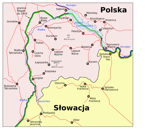
Polish part of Spisz region as of 1924-1938 and after 1945. Polska część Spisza w granicach z lat 1924-1938 i po 1945. Based on / oparte na sk:Obrázok:Polskispisz.gif. |
| Date | 25 March 2006 (original upload date) |
| Source | No machine-readable source provided. Own work assumed (based on copyright claims). |
| Author | No machine-readable author provided. PM assumed (based on copyright claims). |
Licensing
[edit]
| I, the copyright holder of this work, release this work into the public domain. This applies worldwide. In some countries this may not be legally possible; if so: I grant anyone the right to use this work for any purpose, without any conditions, unless such conditions are required by law. |
File history
Click on a date/time to view the file as it appeared at that time.
| Date/Time | Thumbnail | Dimensions | User | Comment | |
|---|---|---|---|---|---|
| current | 17:42, 25 March 2006 | | 656 × 625 (152 KB) | PM (talk | contribs) | Polish part of Spisz region as of 1924-1938 and after 1945. Polska część Spisza w granicach z lat 1924-1938 i po 1945. Based on / oparte na sk:Obrázok:Polskispisz.gif. Category:Historical maps of Slovakia [[Category:Historical maps of |
You cannot overwrite this file.
File usage on Commons
The following page uses this file:
File usage on other wikis
The following other wikis use this file:
- Usage on cs.wikipedia.org
- Usage on de.wikipedia.org
- Usage on pl.wikipedia.org