File:PonticKingdom.png
来自Wikimedia Commons
跳转到导航
跳转到搜索

本预览的尺寸:718 × 600像素。 其他分辨率:287 × 240像素 | 575 × 480像素 | 919 × 768像素 | 1,226 × 1,024像素 | 1,551 × 1,296像素。
原始文件 (1,551 × 1,296像素,文件大小:219 KB,MIME类型:image/png)
文件信息
结构化数据
说明
说明
添加一行文字以描述该文件所表现的内容
摘要
[编辑]
|
此historical map图片可使用矢量图形重新创建为SVG文件。这具有很多好处;更多信息请参见共享资源:待清理媒体。如果存在此图片的SVG格式,请将其上传,然后将此模板替换为
{{vector version available|新图片名称}}。
建议您将SVG命名为“PonticKingdom.svg”,这样在使用Vector version available(或Vva)模板时就不需要填写新图片名称参数。 |
| 描述PonticKingdom.png |
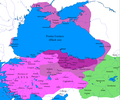
English: Map of the Kingdom of Pontus
|
| 日期 | |
| 来源 | I (Javierfv1212 (talk)) created this work entirely by myself. Sources, Cambridge Ancient history volume 9, Penguin atlas of Greek history and the Foreign Policy of Mithridates VI Eupator. |
| 作者 | Javierfv1212 (talk) |
许可协议
[编辑]| Public domainPublic domainfalsefalse |
| 本作品已被作者英语维基百科的Javierfv1212释出到公有领域。这适用于全世界。 在一些国家这可能不合法;如果是这样的话,那么: Javierfv1212无条件地授予任何人以任何目的使用本作品的权利,除非这些条件是法律规定所必需的。Public domainPublic domainfalsefalse |
原始上传日志
[编辑]Transferred from en.wikipedia to Commons by Falcorian using CommonsHelper.
The original description page was here. All following user names refer to en.wikipedia.
- 2009-07-19 23:42 Javierfv1212 1551×1296× (205182 bytes) {{Information |Description = Map of the Kingdom of Pontus, Before the reign of mithridates VI (darkest purple), after his conquests (purple), and his conquests in the first Mithridatic wars (pink). |Source = I (~~~) created this work entirel
文件历史
点击某个日期/时间查看对应时刻的文件。
| 日期/时间 | 缩略图 | 大小 | 用户 | 备注 | |
|---|---|---|---|---|---|
| 当前 | 2024年11月15日 (五) 13:20 |  | 1,551 × 1,296(219 KB) | GrandEscogriffe(留言 | 贡献) | location of Ancyra |
| 2017年12月9日 (六) 02:00 |  | 1,551 × 1,296(265 KB) | SteinsplitterBot(留言 | 贡献) | Bot: Image rotated by 90° | |
| 2017年12月9日 (六) 00:00 |  | 1,296 × 1,551(316 KB) | SteinsplitterBot(留言 | 贡献) | Bot: Image rotated by 270° | |
| 2016年9月22日 (四) 17:54 |  | 1,551 × 1,296(265 KB) | Hohum(留言 | 贡献) | Lighten water area | |
| 2016年8月9日 (二) 11:21 |  | 1,551 × 1,296(260 KB) | MAXHO(留言 | 贡献) | Details : more cities & shoreline of this time | |
| 2015年10月1日 (四) 20:57 |  | 1,551 × 1,296(249 KB) | Spiridon Ion Cepleanu(留言 | 贡献) | Cosmetic again | |
| 2015年9月30日 (三) 12:55 |  | 1,551 × 1,296(247 KB) | Spiridon Ion Cepleanu(留言 | 贡献) | Cosmetic colours & background names | |
| 2014年4月7日 (一) 14:21 |  | 1,551 × 1,296(225 KB) | Spiridon Ion Cepleanu(留言 | 贡献) | Little changes (ancient shoreline & some greek colonies under Pontic rule) according with V. Yanko-Hombach, A.S. Gilbert, N. Panin, P. M. Dolukhanov: ''The Black Sea Flood Question: Changes in Coastline, Climate, and Human Settlement'', Springer, Nethe... | |
| 2009年7月20日 (一) 04:14 |  | 1,551 × 1,296(200 KB) | File Upload Bot (Magnus Manske)(留言 | 贡献) | {{BotMoveToCommons|en.wikipedia|year={{subst:CURRENTYEAR}}|month={{subst:CURRENTMONTHNAME}}|day={{subst:CURRENTDAY}}}} {{Information |Description={{en|Map of the Kingdom of Pontus, Before the reign of mithridates VI (darkest purple), after his conquests |
您不可以覆盖此文件。
文件用途
全域文件用途
以下其他wiki使用此文件:
- ar.wikipedia.org上的用途
- ast.wikipedia.org上的用途
- azb.wikipedia.org上的用途
- az.wikipedia.org上的用途
- bg.wikipedia.org上的用途
- br.wikipedia.org上的用途
- ca.wikipedia.org上的用途
- cs.wikipedia.org上的用途
- da.wikipedia.org上的用途
- de.wikipedia.org上的用途
- el.wikipedia.org上的用途
- en.wikipedia.org上的用途
- es.wikipedia.org上的用途
- et.wikipedia.org上的用途
- eu.wikipedia.org上的用途
- fa.wikipedia.org上的用途
- fr.wikipedia.org上的用途
查看此文件的更多全域用途。
元数据
此文件含有额外信息,这些信息可能是创建或数字化该文件时使用的数码相机或扫描仪所添加的。如果文件已从其原始状态修改,某些详细信息可能无法完全反映修改后的文件。
| 水平分辨率 | 37.79 dpc |
|---|---|
| 垂直分辨率 | 37.79 dpc |