File:Pontic steppe region around 650 AD-svg-en.svg
Ir a la navegación
Ir a la búsqueda

Tamaño de esta previsualización PNG del archivo SVG: 512 × 444 píxeles. Otras resoluciones: 277 × 240 píxeles | 554 × 480 píxeles | 886 × 768 píxeles | 1181 × 1024 píxeles | 2362 × 2048 píxeles.
Archivo original (archivo SVG, nominalmente 512 × 444 píxeles, tamaño de archivo: 94 kB)
Leyendas
Leyendas
Añade una explicación corta acerca de lo que representa este archivo
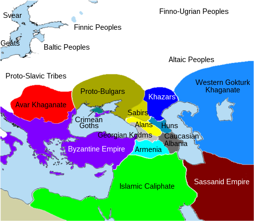
The Pontic steppe region, c. 650 CE (With English names)
Resumen[editar]
| Descripción |
Français : Région de la steppe pontique, v. 650 EC - (Avec noms en anglais)
English: The Pontic steppe region, c. 650 CE (With English names) |
| Fecha | |
| Fuente | Trabajo propio / Trabajo propio, basado en: Pontic steppe region around 650 AD.png / Conversion bitmap (.png) to vector (.svg) |
| Autor | Poudou99 |
Licencia[editar]
Yo, el titular de los derechos de autor de esta obra, la publico en los términos de la siguiente licencia:
Este archivo está disponible bajo la licencia Creative Commons Atribución 4.0 Internacional.
- Eres libre:
- de compartir – de copiar, distribuir y transmitir el trabajo
- de remezclar – de adaptar el trabajo
- Bajo las siguientes condiciones:
- atribución – Debes otorgar el crédito correspondiente, proporcionar un enlace a la licencia e indicar si realizaste algún cambio. Puedes hacerlo de cualquier manera razonable pero no de manera que sugiera que el licenciante te respalda a ti o al uso que hagas del trabajo.
Historial del archivo
Haz clic sobre una fecha y hora para ver el archivo tal como apareció en ese momento.
| Fecha y hora | Miniatura | Dimensiones | Usuario | Comentario | |
|---|---|---|---|---|---|
| actual | 14:58 27 feb 2020 | | 512 × 444 (94 kB) | Poudou99 (discusión | contribs.) | User created page with UploadWizard |
No puedes sobrescribir este archivo.
Usos del archivo
Las siguientes páginas usan este archivo:
Uso global del archivo
Las wikis siguientes utilizan este archivo:
- Uso en en.wikipedia.org
Metadatos
Categorías:
- Maps showing the 650s
- SVG maps of Eurasia
- Maps of the Khazars
- Maps of the history of Bulgars in the 7th century
- Maps showing 7th-century history
- Maps of 7th-century Bulgaria
- Maps of the history of Romania in the Middle Ages
- Maps of the history of Tatarstan
- Maps of Eurasian Avars
- Avar Khaganate
- Maps of Alania
- SVG locator maps of former countries of Europe
- Pontic steppe