File:Port of Dover - view from the White Cliffs-4101-03.jpg
跳至導覽
跳至搜尋
預覽大小:800 × 314 像素。 其他解析度:320 × 125 像素 | 640 × 251 像素 | 1,024 × 401 像素 | 1,280 × 502 像素 | 2,560 × 1,003 像素 | 7,785 × 3,051 像素。
原始檔案 (7,785 × 3,051 像素,檔案大小:3.14 MB,MIME 類型:image/jpeg)
說明
說明
添加單行說明來描述出檔案所代表的內容
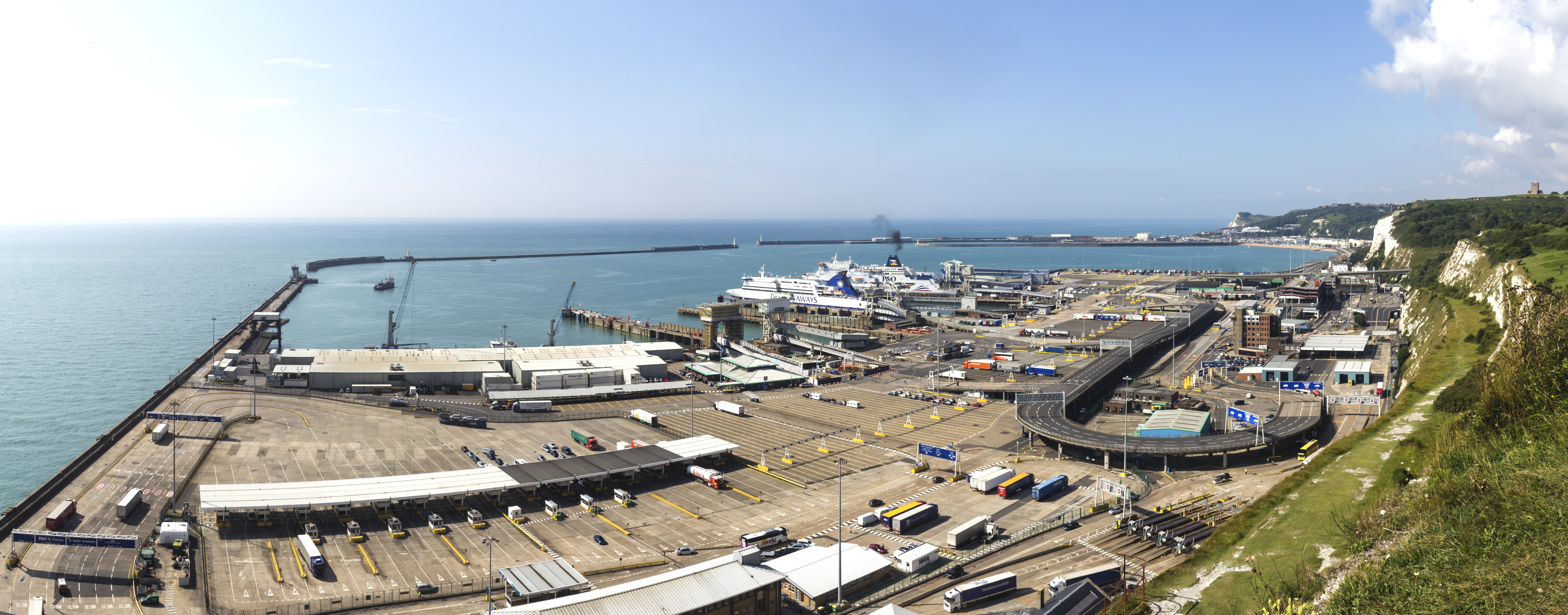
Port of Dover - view from the White Cliffs
摘要
[編輯]| 描述 |
English: Port of Dover - view from the White Cliffs Deutsch: Hafen von Dover. Blick herab von den weißen Klippen von Dover |
|||||||||||||||||
| 日期 | ||||||||||||||||||
| 來源 | 自己的作品 | |||||||||||||||||
| 作者 |
|
|||||||||||||||||
| 其他版本 |
|
|||||||||||||||||
| 姓名標示 (由许可协议要求) | © Raimond Spekking / | |||||||||||||||||


| 拍攝地點 | | 位於此地的本圖片與其他圖片: OpenStreetMap |
|---|

|
注意:这是一张全景图,使用PanoramaStudio将3张图片拼接而成。所以该图片经过了某些数字化的操作。这些操作可能包括混合,模糊,克隆,以及颜色和角度的调整。由于这些调整,图片在接缝处可能和真实照片有一些差异。这些操作往往会带来镜头,透视和视差方面的失真。
|
授權條款
[編輯]
I have published this image as author under the Creative-Commons-Licence CC BY-SA 4.0.. This means that free online usage outside of Wikimedia projects under the following terms of licence is possible:
- The image is credited with "© Raimond Spekking / CC BY-SA 4.0 (via Wikimedia Commons)"
For all other kind of usages (books, journales, flyers, etc.) click on the following button. You will get all information needed.
I would be happy to receive a specimen copy or the URL of the website where the image is used.
Please write an email to raimond.spekking@gmail.com (GPG encrypted emails are welcome: Key-ID: 0xB12BE7A6), if you
- need the image in a higher resolution
- need my postal address for sending a specimen copy
- have further questions to the terms of licence
我,本作品的著作權持有者,決定用以下授權條款發佈本作品:
此檔案採用創用CC 姓名標示-相同方式分享 4.0 國際授權條款。
姓名標示: © Raimond Spekking / CC BY-SA 4.0 (via Wikimedia Commons)
- 您可以自由:
- 分享 – 複製、發佈和傳播本作品
- 重新修改 – 創作演繹作品
- 惟需遵照下列條件:
- 姓名標示 – 您必須指名出正確的製作者,和提供授權條款的連結,以及表示是否有對內容上做出變更。您可以用任何合理的方式來行動,但不得以任何方式表明授權條款是對您許可或是由您所使用。
- 相同方式分享 – 如果您利用本素材進行再混合、轉換或創作,您必須基於如同原先的相同或兼容的條款,來分布您的貢獻成品。
| 註解 | 該圖片含有註解:在維基媒體共享資源上查看註解 |
檔案歷史
點選日期/時間以檢視該時間的檔案版本。
| 日期/時間 | 縮圖 | 尺寸 | 使用者 | 備註 | |
|---|---|---|---|---|---|
| 目前 | 2014年11月6日 (四) 19:04 | 7,785 × 3,051(3.14 MB) | Raymond(留言 | 貢獻) | User created page with UploadWizard |
無法覆蓋此檔案。
檔案用途
下列3個頁面有用到此檔案:
全域檔案使用狀況
以下其他 wiki 使用了這個檔案:
- bn.wikipedia.org 的使用狀況
- ceb.wikipedia.org 的使用狀況
- de.wikipedia.org 的使用狀況
- de.wiktionary.org 的使用狀況
- en.wikipedia.org 的使用狀況
- eu.wikipedia.org 的使用狀況
- fi.wikipedia.org 的使用狀況
- fr.wikipedia.org 的使用狀況
- gv.wikipedia.org 的使用狀況
- hak.wikipedia.org 的使用狀況
- he.wikipedia.org 的使用狀況
- hi.wikipedia.org 的使用狀況
- lt.wikipedia.org 的使用狀況
- no.wikipedia.org 的使用狀況
- pt.wiktionary.org 的使用狀況
- sr.wikipedia.org 的使用狀況
- ta.wikipedia.org 的使用狀況
- www.wikidata.org 的使用狀況
- yi.wikipedia.org 的使用狀況
- zh.wikipedia.org 的使用狀況
- zh.wiktionary.org 的使用狀況