File:Port of Rotterdam Landsat 8 Photo 8 May 2016.jpg
Jump to navigation
Jump to search

Size of this preview: 800 × 252 pixels. Other resolutions: 320 × 101 pixels | 640 × 201 pixels | 1,024 × 322 pixels | 1,280 × 403 pixels | 5,016 × 1,578 pixels.
Original file (5,016 × 1,578 pixels, file size: 6.73 MB, MIME type: image/jpeg)
Captions
Captions
Add a one-line explanation of what this file represents
Summary[edit]
| Description |
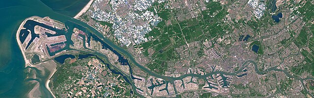
English: Satellite photo of the Port of Rotterdam in South Holland, the Netherlands. This image was captured on May 8, 2016 by the Operational Land Imager (OLI) on the Landsat 8 satellite.
Nederlands: Satellietfoto van de haven van Rotterdam in Zuid-Holland, Nederland. Deze foto is op 8 mei 2016 gemaakt door de Operational Land Imager (OLI) op de Landsat 8 satelliet. |
| Date | |
| Source | NASA Earth Observatory - https://earthobservatory.nasa.gov/images/91317/holland-first-stop-for-the-pilgrims |
| Author | NASA Earth Observatory images by Joshua Stevens, using Landsat data from the U.S. Geological Survey. Story by Adam Voiland. |
Licensing[edit]
| This file is in the public domain in the United States because it was solely created by NASA. NASA copyright policy states that "NASA material is not protected by copyright unless noted". (See Template:PD-USGov, NASA copyright policy page or JPL Image Use Policy.) | ||
 |
Warnings:
|
File history
Click on a date/time to view the file as it appeared at that time.
| Date/Time | Thumbnail | Dimensions | User | Comment | |
|---|---|---|---|---|---|
| current | 19:47, 24 June 2023 | 5,016 × 1,578 (6.73 MB) | Artanisen (talk | contribs) | Uploaded a work by NASA Earth Observatory images by Joshua Stevens, using Landsat data from the U.S. Geological Survey. Story by Adam Voiland. from NASA Earth Observatory - https://earthobservatory.nasa.gov/images/91317/holland-first-stop-for-the-pilgrims with UploadWizard |
You cannot overwrite this file.
File usage on Commons
The following 9 pages use this file:
- Europoort
- Port of Rotterdam
- Rotterdam
- File:Rotterdam by Sentinel-2, 2018-06-30.jpg
- File:Satellite image of Europoort, Netherlands (4.25E 51.90N).png
- Category:Aker Wayfarer (ship, 2010) in Rotterdam
- Category:Harbour entrance lights in Port of Rotterdam
- Category:Port of Rotterdam
- Category:Shipping containers in Port of Rotterdam
.png)
File usage on other wikis
The following other wikis use this file:
- Usage on ar.wikipedia.org
- Usage on ast.wikipedia.org
- Usage on ba.wikipedia.org
- Usage on bn.wikipedia.org
- Usage on ca.wikipedia.org
- Usage on cs.wikipedia.org
- Usage on de.wikipedia.org
- Usage on el.wikipedia.org
- Usage on en.wikipedia.org
- Usage on eo.wikipedia.org
- Usage on es.wikipedia.org
- Usage on eu.wikipedia.org
- Usage on fi.wikipedia.org
- Usage on fr.wikipedia.org
- Usage on he.wikipedia.org
- Usage on hu.wikipedia.org
- Usage on id.wikipedia.org
- Usage on is.wikipedia.org
- Usage on it.wikipedia.org
- Usage on ko.wikipedia.org
- Usage on li.wikipedia.org
- Usage on ms.wikipedia.org
- Usage on nds.wikipedia.org
- Usage on nl.wikipedia.org
- Usage on oc.wikipedia.org
- Usage on pl.wikipedia.org
- Usage on pt.wikipedia.org
View more global usage of this file.