File:Porter1796WesternReserve-300.jpg
跳转到导航
跳转到搜索

本预览的尺寸:800 × 534像素。 其他分辨率:320 × 213像素 | 640 × 427像素 | 1,024 × 683像素 | 1,280 × 854像素 | 2,560 × 1,707像素 | 7,403 × 4,937像素。
原始文件 (7,403 × 4,937像素,文件大小:6.67 MB,MIME类型:image/jpeg)
说明
说明
添加一行文字以描述该文件所表现的内容
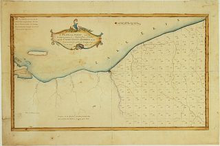
| 描述 | A Plan of the Survey made by & under the direction of Augustus Porter upon the Connecticut-Reserve for the Connecticut Land Company in the Year 1796. Showing the Western Reserve divided into sections and the town and city of Cleaveland (Cleveland) |
| 日期 | |
| 来源 | William L. Clements Library (University of Michigan) |
| 作者 | Augustus Porter |
| 其他版本 | http://www.railsandtrails.com/Maps/Porter1796WesternReserve/index.htm |
|
本作品在其来源国以及其他著作权期限是作者逝世后100年或以下的国家和地区属于公有领域。 | |
| 本文件已被确认为免除已知的著作权法限制(包括所有相关权利)。 | |
文件历史
点击某个日期/时间查看对应时刻的文件。
| 日期/时间 | 缩略图 | 大小 | 用户 | 备注 | |
|---|---|---|---|---|---|
| 当前 | 2010年10月13日 (三) 23:43 | | 7,403 × 4,937(6.67 MB) | Scewing(留言 | 贡献) | {{Information |Description=A Plan of the Survey made by & under the direction of Augustus Porter upon the Connecticut-Reserve for the Connecticut Land Company in the Year 1796. Showing the Western Reserve divided into sections and the town and city of Cle |
您不可以覆盖此文件。
文件用途
没有页面使用本文件。
全域文件用途
以下其他wiki使用此文件:
- en.wikipedia.org上的用途
- ja.wikipedia.org上的用途
- zh.wikipedia.org上的用途