File:PortlandCanalEntrance.jpg
Zur Navigation springen
Zur Suche springen

Größe dieser Vorschau: 800 × 214 Pixel. Weitere Auflösungen: 320 × 86 Pixel | 640 × 171 Pixel | 1.024 × 274 Pixel | 1.280 × 343 Pixel | 5.460 × 1.461 Pixel.
Originaldatei (5.460 × 1.461 Pixel, Dateigröße: 5,19 MB, MIME-Typ: image/jpeg)
Bildtexte
Kurzbeschreibungen
Ergänze eine einzeilige Erklärung, was diese Datei darstellt.
Beschreibung[Bearbeiten]
| Beschreibung |
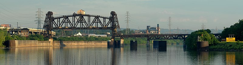
English: This is a panoramic image of the east entrance to the Portland canal, Louisville, Kentucky. The canal, in conjunction with the McAlpine Locks and Dam, provides a navigable route around the Falls of the Ohio. The vertical lift section of the 14th street bridge is in the raised position and is lowered for train traffic.
Français : Vue panoramique sur l'entrée est du Louisville and Portland Canal, ainsi que des écluses du McAlpine Locks and Dam à Louisville, dans le Kentucky (États-Unis). Ce canal et cette série d'écluses contournent un rapide de la rivière Ohio. Le pont levant de la 14e rue est en position haute, il est abaissé pour le passage des trains.
Diese Grafik wurde mit Hugin erstellt. |
| Datum | |
| Quelle | Eigenes Werk |
| Urheber | Joe Schneid, Louisville, Kentucky |
|

| Kameraposition | | Dieses und weitere Bilder auf OpenStreetMap |
|---|
Lizenz[Bearbeiten]
Ich, der Urheber dieses Werkes, veröffentliche es unter der folgenden Lizenz:
Diese Datei ist unter der Creative-Commons-Lizenz „Namensnennung 3.0 nicht portiert“ lizenziert.
- Dieses Werk darf von dir
- verbreitet werden – vervielfältigt, verbreitet und öffentlich zugänglich gemacht werden
- neu zusammengestellt werden – abgewandelt und bearbeitet werden
- Zu den folgenden Bedingungen:
- Namensnennung – Du musst angemessene Urheber- und Rechteangaben machen, einen Link zur Lizenz beifügen und angeben, ob Änderungen vorgenommen wurden. Diese Angaben dürfen in jeder angemessenen Art und Weise gemacht werden, allerdings nicht so, dass der Eindruck entsteht, der Lizenzgeber unterstütze gerade dich oder deine Nutzung besonders.
Dieses Bild wurde unter Berücksichtigung der Leitlinie für Qualitätsbilder bewertet und gilt als Qualitätsbild.
|
| Bildnotizen | Diese Datei ist annotiert: Betrachte diese auf Commons. |
Dateiversionen
Klicke auf einen Zeitpunkt, um diese Version zu laden.
| Version vom | Vorschaubild | Maße | Benutzer | Kommentar | |
|---|---|---|---|---|---|
| aktuell | 22:51, 23. Mai 2009 | 5.460 × 1.461 (5,19 MB) | JMSchneid (Diskussion | Beiträge) | {{Information |Description={{en|1=This is a panoramic image of the east entrance to the Portland canal, Louisville, Kentucky. The canal, in conjunction with the McAlpine Locks and Dam, provides a navigable route around the Falls of the Ohio. The vertical |
Du kannst diese Datei nicht überschreiben.
Dateiverwendung
Die folgenden 26 Seiten verwenden diese Datei:
- Canal
- User:JMSchneid
- User:Ö/Best/2010
- User talk:JMSchneid
- Commons:Featured picture candidates/File:PortlandCanalEntrance.jpg
- Commons:Featured picture candidates/Log/March 2010
- Commons:Featured pictures/Places/Architecture/Bridges
- Commons:Featured pictures/Places/Panoramas
- Commons:Featured pictures/chronological/2010-A
- Commons:Picture of the Year/2010/Galleries/2010-A
- Commons:Picture of the Year/2010/Galleries/All
- Commons:Picture of the Year/2010/Galleries/Index/3
- Commons:Picture of the Year/2010/Galleries/Index/Panoramas
- Commons:Picture of the Year/2010/Galleries/Panoramas
- Commons:Picture of the Year/2010/Galleries/Panoramas/Large
- Commons:Picture of the Year/2010/Galleries/Panoramas/Small
- Commons:Picture of the Year/2010/Galleries/Table
- Commons:Picture of the Year/2010/Galleries/Table/03
- Commons:Picture of the Year/2010/R1/File:PortlandCanalEntrance.jpg
- Commons:Picture of the Year/2010/Results/R1/ALL/Table
- Commons:Picture of the Year/2010/Results/R1/Panoramas
- Commons:Picture of the Year/2010/Results/R1/Panoramas/Table
- Commons:Quality images/Subject/Places/Man made structures/Panorama/archive 2008 to 2013
- Commons:Quality images candidates/Archives June 2009
- Commons talk:Picture of the Year/2010/Galleries/Table
- Commons talk:Picture of the Year/2010/Results/R1/ALL/Table
Globale Dateiverwendung
Die nachfolgenden anderen Wikis verwenden diese Datei:
- Verwendung auf de.wikipedia.org
- Verwendung auf en.wikipedia.org
- Verwendung auf fa.wikipedia.org
- Verwendung auf fr.wikipedia.org
- Verwendung auf pl.wikipedia.org
- Verwendung auf sr.wikipedia.org
- Verwendung auf sv.wikipedia.org
- Verwendung auf vi.wikipedia.org