File:Pre-eruption Pinatubo.jpg

Pre-eruption_Pinatubo.jpg (500 × 334 Pixel, Dateigröße: 69 KB, MIME-Typ: image/jpeg)
Bildtexte
Kurzbeschreibungen
| Beschreibung |
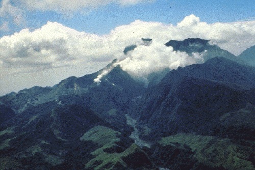
Mount Pinatubo in April 1991, before the onset of magmatic eruptions. Preeruption Mount Pinatubo, April 16, 1991. View from the northwest, up the Maraunot River valley. The river had become acidic and silty, owing to reactivation of the hydrothermal system and phreatic explosions of April 2, 1991 (the vents of which were just out of view at left edge of photograph). Steam was from 2-week-old fumaroles on the upper north slope of the volcano. The fumarole farthest to the right (behind a jagged ridge, right of the one visible on the valley floor) would later become the site of the preclimactic lava dome extrusion of June 7-12 (Hoblitt, Wolfe, and others, this volume). Mount Negron is behind and to the right of Pinatubo. (R.S. Punongbayan) |
| Datum | |
| Quelle | Figure 2A on Photographic Record of Rapid Geomorphic Change at Mount Pinatubo, 1991-94 |
| Urheber | United States Geological Survey |
Dieses Bild ist gemeinfrei (public domain), weil es Materialien beeinhaltet, die ursprünglich vom United States Geological Survey, einer Behörde des Innenministeriums der Vereinigten Staaten, stammen. Weitere Informationen finden Sie in den Urheberrechtsbestimmungen des USGS
|
Dateiversionen
Klicke auf einen Zeitpunkt, um diese Version zu laden.
| Version vom | Vorschaubild | Maße | Benutzer | Kommentar | |
|---|---|---|---|---|---|
| aktuell | 18:57, 12. Okt. 2005 | | 500 × 334 (69 KB) | Ascánder (Diskussion | Beiträge) | Mount Pinatubo in April 1991, before the onset of magmatic eruptions. (Probable) source: [http://pubs.usgs.gov/pinatubo/punong1/fig2a.jpg Fig.2A] on [http://pubs.usgs.gov/pinatubo/punong1/index.html] {{PD-USGov-Interior-USGS}} [[Category:Philippines] |
Du kannst diese Datei nicht überschreiben.
Dateiverwendung
Keine Seiten verwenden diese Datei.
Globale Dateiverwendung
Die nachfolgenden anderen Wikis verwenden diese Datei:
- Verwendung auf az.wikipedia.org
- Verwendung auf bg.wikipedia.org
- Verwendung auf cs.wikipedia.org
- Verwendung auf en.wikipedia.org
- Verwendung auf es.wikipedia.org
- Verwendung auf fi.wikipedia.org
- Verwendung auf fr.wikipedia.org
- Verwendung auf he.wikipedia.org
- Verwendung auf hy.wikipedia.org
- Verwendung auf io.wikipedia.org
- Verwendung auf it.wikipedia.org
- Verwendung auf ja.wikipedia.org
- Verwendung auf ka.wikipedia.org
- Verwendung auf kk.wikipedia.org
- Verwendung auf lt.wikipedia.org
- Verwendung auf nl.wikipedia.org
- Verwendung auf no.wikipedia.org
- Verwendung auf pam.wikipedia.org
- Verwendung auf pl.wikipedia.org
- Verwendung auf ru.wikipedia.org
- Verwendung auf sk.wikipedia.org
- Verwendung auf sr.wikipedia.org