File:Prevenza - 38-39.jpg

Πρωτότυπο αρχείο (3.897 × 5.001 εικονοστοιχεία, μέγεθος αρχείου: 1,46 MB, τύπος MIME: image/jpeg)
Λεζάντες
Λεζάντες
|
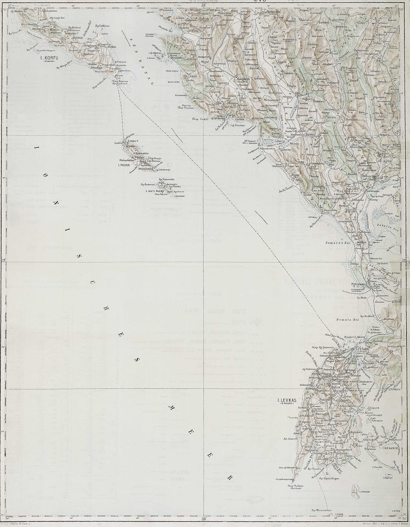
Deutsch: Blatt 38-39 der Generalkarte von Mitteleuropa 1:200.000 der Franzisco-Josephinischen Landesaufnahme, Österreich-Ungarn, ab 1887. Die Blattmitte liegt bei 39° n.Br. und 38° ö.L. (östlich von Ferro, nicht Greenwich!). English: Sheet 38-39 of the General Map of Central Europe, scale 1:200,000, edited 1887 ff. See 3rd Military Mapping Survey of Austria-Hungary for details. The center of the sheet is 39° North, 38° East (east of Ferro, not Greenwich!).
← Nachbarblätter. Klicken Sie auf eine Miniatur, um zu diesem Blatt zu gelangen.
← Neighbouring sheets. Click thumbnail to navigate |


.jpg)
Σύνοψη[επεξεργασία]
| Περιγραφή | 3rd Military Mapping Survey of Austria-Hungary - Prevenza |
| Ημερομηνία | |
| Πηγή | http://lazarus.elte.hu/hun/moterkep.htm - László ZENTAI |
| Δημιουργός | Military mapping authority of Austria-Hungary |
Αδειοδότηση[επεξεργασία]
|
Αυτό το έργο είναι κοινό κτήμα στη χώρα προέλευσής του και άλλες χώρες και περιοχές όπου η διάρκεια πνευματικών δικαιωμάτων είναι όσο η ζωή του δημιουργού και μέχρι 70 χρόνια μετά ή λιγότερο.
| |
| Αυτό το αρχείο έχει χαρακτηριστεί ως απαλλαγμένο από γνωστούς περιορισμούς βάσει της νομοθεσίας περί πνευματικής ιδιοκτησίας, περιλαμβανομένων όλων των συναφών και συγγενικών δικαιωμάτων. | |
Ιστορικό αρχείου
Πατήστε σε μια ημερομηνία/ώρα για να δείτε το αρχείο όπως εμφανιζόταν εκείνη την χρονική στιγμή.
| Ημερομηνία/Ώρα | Μικρογραφία | Διαστάσεις | Χρήστης | Σχόλιο | |
|---|---|---|---|---|---|
| τρέχον | 08:13, 21 Μαρτίου 2007 | | 3.897 × 5.001 (1,46 MB) | Szilas (συζήτηση | Συνεισφορά) | == Összefoglaló == 3rd Military Mapping Survey of Austria-Hungary - Prevenza Source: http://lazarus.elte.hu/hun/moterkep.htm - László ZENTAI Category:3rd Military Mapping Survey of Austria-Hungary == Licensing == {{PD-old}} |
Δεν μπορείτε να αντικαταστήσετε αυτό το αρχείο.
Χρήση αρχείου
Οι ακόλουθες 5 σελίδες χρησιμοποιούν προς αυτό το αρχείο:
Καθολική χρήση αρχείου
Τα ακόλουθα άλλα wiki χρησιμοποιούν αυτό το αρχείο:
- Χρήση σε de.wikipedia.org
- Χρήση σε el.wikipedia.org
- Χρήση σε hu.wikibooks.org