File:Proxad FR.svg
From Wikimedia Commons, the free media repository
Jump to navigation
Jump to search

Size of this PNG preview of this SVG file: 607 × 600 pixels. Other resolutions: 243 × 240 pixels | 486 × 480 pixels | 777 × 768 pixels | 1,036 × 1,024 pixels | 2,073 × 2,048 pixels | 2,700 × 2,668 pixels.
Original file (SVG file, nominally 2,700 × 2,668 pixels, file size: 1.35 MB)
File information
Structured data
Captions
Captions
Add a one-line explanation of what this file represents
Summary
[edit]| DescriptionProxad FR.svg |
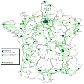
Français : Une carte de France avec les implantations réseaux (PoP, point de présence) de Iliad/Free.
A noter que les vus sont au niveau de la couche TCP/IP (la couche optique étant transparente). Aussi l'Ilde de France est grandement simplifiée, ne montrant que les plus gros PoP (TH1 = Telehouse 1, TH2 = Telehouse 2, CBV = Courbevoie, BZN = Bezon) |
| Date | |
| Source | File:Départements de France.svg |
| Author | Ludovic.ferre |
France
Licensing
[edit]| Public domainPublic domainfalsefalse |
| I, the copyright holder of this work, release this work into the public domain. This applies worldwide. In some countries this may not be legally possible; if so: I grant anyone the right to use this work for any purpose, without any conditions, unless such conditions are required by law. |
File history
Click on a date/time to view the file as it appeared at that time.
| Date/Time | Thumbnail | Dimensions | User | Comment | |
|---|---|---|---|---|---|
| current | 13:29, 9 June 2015 |  | 2,700 × 2,668 (1.35 MB) | Pic-Sou (talk | contribs) | correcting cities names, adding a lacking DSLG POP |
| 05:44, 10 May 2010 |  | 2,700 × 2,668 (1.36 MB) | Ludovic.ferre (talk | contribs) | Adding peering and transit sites. | |
| 07:07, 9 May 2010 |  | 2,700 × 2,668 (1.33 MB) | Ludovic.ferre (talk | contribs) | Changed PoP size and added legend. Also changed main color theme. | |
| 22:22, 3 May 2010 |  | 2,700 × 2,668 (1.27 MB) | Ludovic.ferre (talk | contribs) | Too many to list here ;). | |
| 15:42, 2 May 2010 |  | 2,700 × 2,668 (547 KB) | Ludovic.ferre (talk | contribs) | {{Information |Description={{fr|1=Une carte de France avec les implantations réseaux (PoP, point de présence) de Iliad/Free. A noter que les vus sont au niveau de la couche TCP/IP (la couche optique étant transparente). Aussi l'Ilde de France est gran |
You cannot overwrite this file.
File usage on Commons
The following page uses this file:
File usage on other wikis
The following other wikis use this file:
- Usage on en.wikipedia.org
- Usage on eo.wikipedia.org
- Usage on fr.wikipedia.org
Metadata
This file contains additional information such as Exif metadata which may have been added by the digital camera, scanner, or software program used to create or digitize it. If the file has been modified from its original state, some details such as the timestamp may not fully reflect those of the original file. The timestamp is only as accurate as the clock in the camera, and it may be completely wrong.
| Width | 2700 |
|---|---|
| Height | 2668 |
Structured data
Items portrayed in this file
depicts
some value
2 May 2010
1,415,369 byte
image/svg+xml
ceaf7c1722f7b546b559b4dcf5c999126039c253
Hidden categories: