File:Przytyk (gmina) location map.png
Jump to navigation
Jump to search
Size of this preview: 662 × 600 pixels. Other resolutions: 265 × 240 pixels | 530 × 480 pixels | 882 × 799 pixels.
Original file (882 × 799 pixels, file size: 196 KB, MIME type: image/png)
Captions
Captions
Add a one-line explanation of what this file represents
| Description |
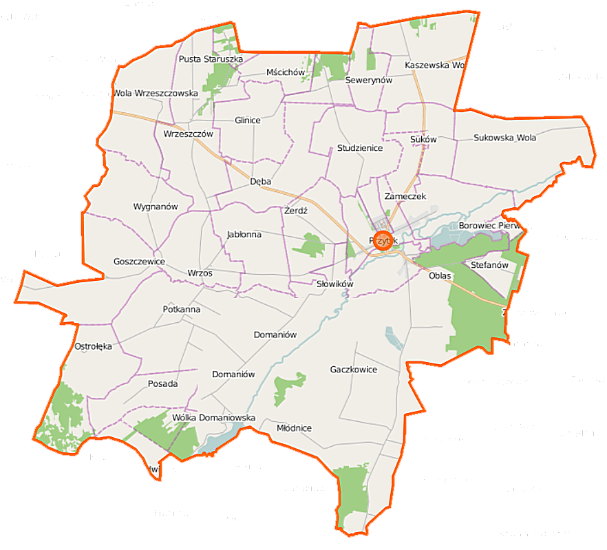
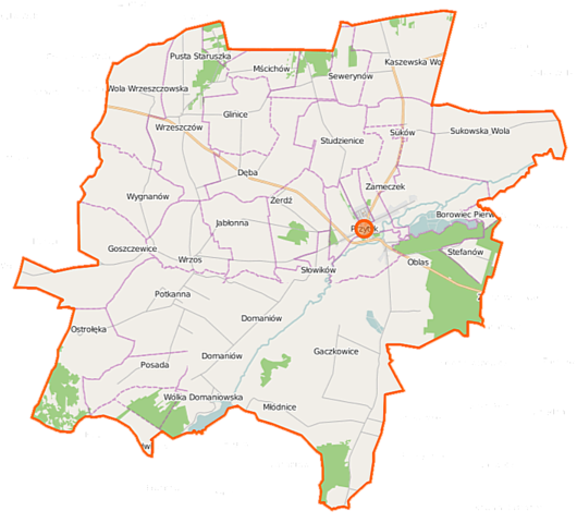
Polski: Mapa gminy Przytyk, Polska
English: Map of Gmina Przytyk, Poland |
|||||||||
| Date | ||||||||||
| Source | You may find a page on the OpenStreetMap wiki page for Przytyk (gmina) | |||||||||
| Creator |
OpenStreetMap contributors OpenStreetMap contributors |
|||||||||
| Permission (Reusing this file) |
OpenStreetMap data is available under the Open Database License (details). Map tiles are licensed under the Creative Commons Attribution-ShareAlike 2.0 license (CC-BY-SA 2.0).
This file is licensed under the Creative Commons Attribution-Share Alike 2.0 Generic license.
|
|||||||||
| Geotemporal data | ||||||||||
| Bounding box |
|
|||||||||
| Georeferencing | If inappropriate please set warp_status = skip to hide. | |||||||||
File history
Click on a date/time to view the file as it appeared at that time.
| Date/Time | Thumbnail | Dimensions | User | Comment | |
|---|---|---|---|---|---|
| current | 05:40, 1 October 2014 | | 882 × 799 (196 KB) | VanWiel (talk | contribs) | {{OpenStreetMap | name = Przytyk (gmina) | location = Przytyk (gmina) | description = {{pl|Mapa gminy Przytyk, Polska}} {{en|Map of Gmina Przytyk, Poland}} | top = 51.5280 | left = 20.7511 | right... |
You cannot overwrite this file.
File usage on Commons
There are no pages that use this file.
File usage on other wikis
The following other wikis use this file:
- Usage on fr.wikipedia.org
- Usage on pl.wikipedia.org
- Przytyk (gmina)
- Gaczkowice
- Glinice (województwo mazowieckie)
- Goszczewice
- Kaszewska Wola
- Młódnice
- Mścichów
- Oblas (wieś)
- Podgajek
- Potkanna
- Przytyk
- Sukowska Wola
- Wola Wrzeszczowska
- Wólka Domaniowska
- Wrzeszczów
- Wrzos (województwo mazowieckie)
- Dęba (województwo mazowieckie)
- Domaniów (województwo mazowieckie)
- Krzyszkowice (województwo mazowieckie)
- Posada (województwo mazowieckie)
- Słowików (województwo mazowieckie)
- Studzienice (województwo mazowieckie)
- Suków (województwo mazowieckie)
- Wygnanów (województwo mazowieckie)
- Zameczek (województwo mazowieckie)
- Żerdź (województwo mazowieckie)
- Jabłonna (powiat radomski)
- Maksymilianów (powiat radomski)
- Ostrołęka (powiat radomski)
- Sewerynów (powiat radomski)
- Stefanów (powiat radomski)
- Witoldów (powiat radomski)
- Duży Las
- Jadwiniów
- Jagodno (województwo mazowieckie)
- Zameczek-Kolonia
- Oblas (osada leśna)
- Stary Młyn (województwo mazowieckie)
- Żmijków
- Cmentarz żydowski w Przytyku
- Parafia Podwyższenia Krzyża Świętego w Przytyku
- Parafia św. Marii Magdaleny we Wrzeszczowie
- Parafia św. Wawrzyńca we Wrzosie
- Borowiec Pierwszy
- Podgajek-Kolonia
- Kościół Podwyższenia Krzyża Świętego w Przytyku
- Moduł:Mapa/dane/Przytyk (gmina)
- Babia Góra (Ostrołęka)
- Moduł:Mapa/dane/Przytyk
View more global usage of this file.
_location_map.png)
_location_map.png&oldid=519993141)