File:Puck (gmina wiejska) location map.png
Jump to navigation
Jump to search

Size of this preview: 521 × 600 pixels. Other resolutions: 208 × 240 pixels | 417 × 480 pixels | 947 × 1,090 pixels.
Original file (947 × 1,090 pixels, file size: 121 KB, MIME type: image/png)
Captions
Captions
Add a one-line explanation of what this file represents
| Description |
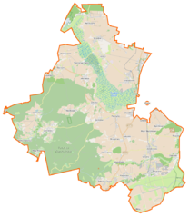
Polski: Mapa gminy Puck, Polska
English: Map of Gmina Puck, Poland |
|||||||||
| Date | ||||||||||
| Source | You may find a page on the OpenStreetMap wiki page for Puck (gmina wiejska) | |||||||||
| Creator |
OpenStreetMap contributors OpenStreetMap contributors |
|||||||||
| Permission (Reusing this file) |
OpenStreetMap data is available under the Open Database License (details). Map tiles are licensed under the Creative Commons Attribution-ShareAlike 2.0 license (CC-BY-SA 2.0).
This file is licensed under the Creative Commons Attribution-Share Alike 2.0 Generic license.
|
|||||||||
| Geotemporal data | ||||||||||
| Bounding box |
|
|||||||||
| Georeferencing | If inappropriate please set warp_status = skip to hide. | |||||||||
File history
Click on a date/time to view the file as it appeared at that time.
| Date/Time | Thumbnail | Dimensions | User | Comment | |
|---|---|---|---|---|---|
| current | 08:35, 29 January 2015 | | 947 × 1,090 (121 KB) | VanWiel (talk | contribs) | {{OpenStreetMap | name = Puck (gmina wiejska) | location = Puck (gmina wiejska) | description = {{pl|Mapa gminy Puck, Polska}} {{en|Map of Gmina Puck, Poland}} | top = 54.8228 | bottom = 54.6069 | l... |
You cannot overwrite this file.
File usage on Commons
There are no pages that use this file.
File usage on other wikis
The following other wikis use this file:
- Usage on cs.wikipedia.org
- Usage on de.wikipedia.org
- Usage on fr.wikipedia.org
- Beka (Poméranie)
- Błądzikowo
- Brudzewo (Poméranie)
- Celbówko
- Celbowo
- Czarna Góra (Puck)
- Czarny Młyn (Puck)
- Czechy (Poméranie)
- Dana (Poméranie)
- Darżlubie
- Domatówko
- Domatowo
- Głuszewo
- Gnieżdżewo
- Kaczyniec (Poméranie)
- Łebcz
- Leśniewo (Poméranie)
- Łyśniewo
- Mała Piaśnica
- Mechowo (Poméranie)
- Mieroszyno
- Mieroszyno-Wybudowanie
- Moście Błota
- Mrzezino
- Muza (Poméranie)
- Osłonino
- Podgóry (Puck)
- Połchowo (Poméranie)
- Połczyno (Poméranie)
- Pustki (Puck)
- Radoszewo
- Rekowo Górne
- Rzucewo
- Sikorzyno (Puck)
- Sławutówko
- Sławutowo
- Smolno (Poméranie)
- Starzyno (Poméranie)
- Starzyński Dwór
- Strzelno (Poméranie)
- Swarzewo
- Werblinia
- Widlino (Puck)
- Zdrada (Poméranie)
- Zele (Pologne)
- Żelistrzewo
- Usage on mk.wikipedia.org
- Usage on pl.wikipedia.org
View more global usage of this file.
_location_map.png)
_location_map.png&oldid=519993270)