File:Punta Patache, Chile.jpg
Jump to navigation
Jump to search

Size of this preview: 800 × 450 pixels. Other resolutions: 320 × 180 pixels | 640 × 360 pixels | 1,024 × 576 pixels | 1,280 × 720 pixels | 2,610 × 1,468 pixels.
Original file (2,610 × 1,468 pixels, file size: 1.05 MB, MIME type: image/jpeg)
Captions
Captions
Add a one-line explanation of what this file represents
Summary
[edit]
| Description |
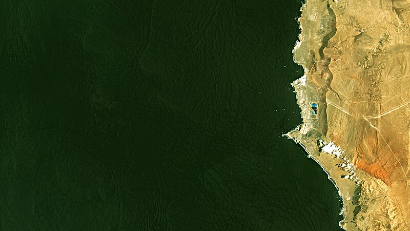
Português: Punta Patache na costa N do Chile no Oceano Pacífico. No mar, que aparece em cor preta a cinza escura com padrões revelando a ondulação, pontos brancos são navios cargueiros esperando para carregar minério de cobre no Terminal Marítimo da Mina Collahuasi; linhas brancas na costa é espuma de ondas quebrando. No continente , deserto em marrom a amarelo; linha amarela mais grossa é a estrada de serviço do mineroduto que vem da mina localizada a 4.400m de altitude, no Altiplano do Atacama. No centro da imagem, parte sob nuvens em cor branca com sombras em preto, está o Oasis de Niebla Alto Patache, ecossistema no deserto onde umidade da névoa marinha se condensa e permite a existência de vegetação, daí sua cor levemente esverdeada / Punta Patache Port at Chile´s N Pacific coast. At sea, appearing in colors from black to dark grey due to swell, white dots are ships waiting to load copper ore at Collahuasi Mine Maritime Terminal; white lines following coast are crashing waves foam. On land, desert in brown to yellow; thickest yellow line is Collahuasi Mine cooper ore overland conveyor service road, coming from 15,000 ft high mine at Atacama highlands. At image center, part under clouds in white with its shadows in black, is Alto Patache Fog Oasis, small desert ecossystem where sea fog humidity condenses enabling some vegetation growth, them its lightly greenish color.
+info: 1) Oásis de Névoa 2) Mina Collahuasi 3) Foto aérea do Terminal Marítimo
Imagem / Image CBERS4 MUX Punta Patache, Chile Coordenadas do centro da imagem / Image center: 20°49'00.3"S 70°09'46.8"W Data / Date: 08-01-2020 / 2020-08-01 RGB 765 (cor verdadeira / true color) Cena / Scene: 180 / 123 Autor / Author: Oton Barros (DSR/OBT/INPE) Imagem em HD / HD Image Visite-nos em www.dsr.inpe.br |
| Date | |
| Source | https://www.flickr.com/photos/153282474@N02/49357622872/ |
| Author | Coordenação-Geral de Observação da Terra/INPE |
Licensing
[edit]
This file is licensed under the Creative Commons Attribution-Share Alike 2.0 Generic license.
- You are free:
- to share – to copy, distribute and transmit the work
- to remix – to adapt the work
- Under the following conditions:
- attribution – You must give appropriate credit, provide a link to the license, and indicate if changes were made. You may do so in any reasonable manner, but not in any way that suggests the licensor endorses you or your use.
- share alike – If you remix, transform, or build upon the material, you must distribute your contributions under the same or compatible license as the original.
| This image was originally posted to Flickr by Coordenação-Geral de Observação da Terra/INPE at https://flickr.com/photos/153282474@N02/49357622872. It was reviewed on 9 April 2020 by FlickreviewR 2 and was confirmed to be licensed under the terms of the cc-by-sa-2.0. |
File history
Click on a date/time to view the file as it appeared at that time.
| Date/Time | Thumbnail | Dimensions | User | Comment | |
|---|---|---|---|---|---|
| current | 10:12, 9 April 2020 | | 2,610 × 1,468 (1.05 MB) | Jo-Jo Eumerus (talk | contribs) | Uploaded a work by Coordenação-Geral de Observação da Terra/INPE from https://www.flickr.com/photos/153282474@N02/49357622872/ with UploadWizard |
You cannot overwrite this file.
File usage on Commons
The following page uses this file:
- File:Punta Patache, Chile (49357622872).jpg (file redirect)
.jpg&redirect=no)