File:Purposed Outer Ring Road.jpg
Jump to navigation
Jump to search

Size of this preview: 800 × 531 pixels. Other resolutions: 320 × 212 pixels | 640 × 425 pixels | 1,024 × 680 pixels | 1,280 × 850 pixels | 2,341 × 1,554 pixels.
Original file (2,341 × 1,554 pixels, file size: 373 KB, MIME type: image/jpeg)
Captions
Captions
Outer Ring Road
Summary
[edit]
| Description |
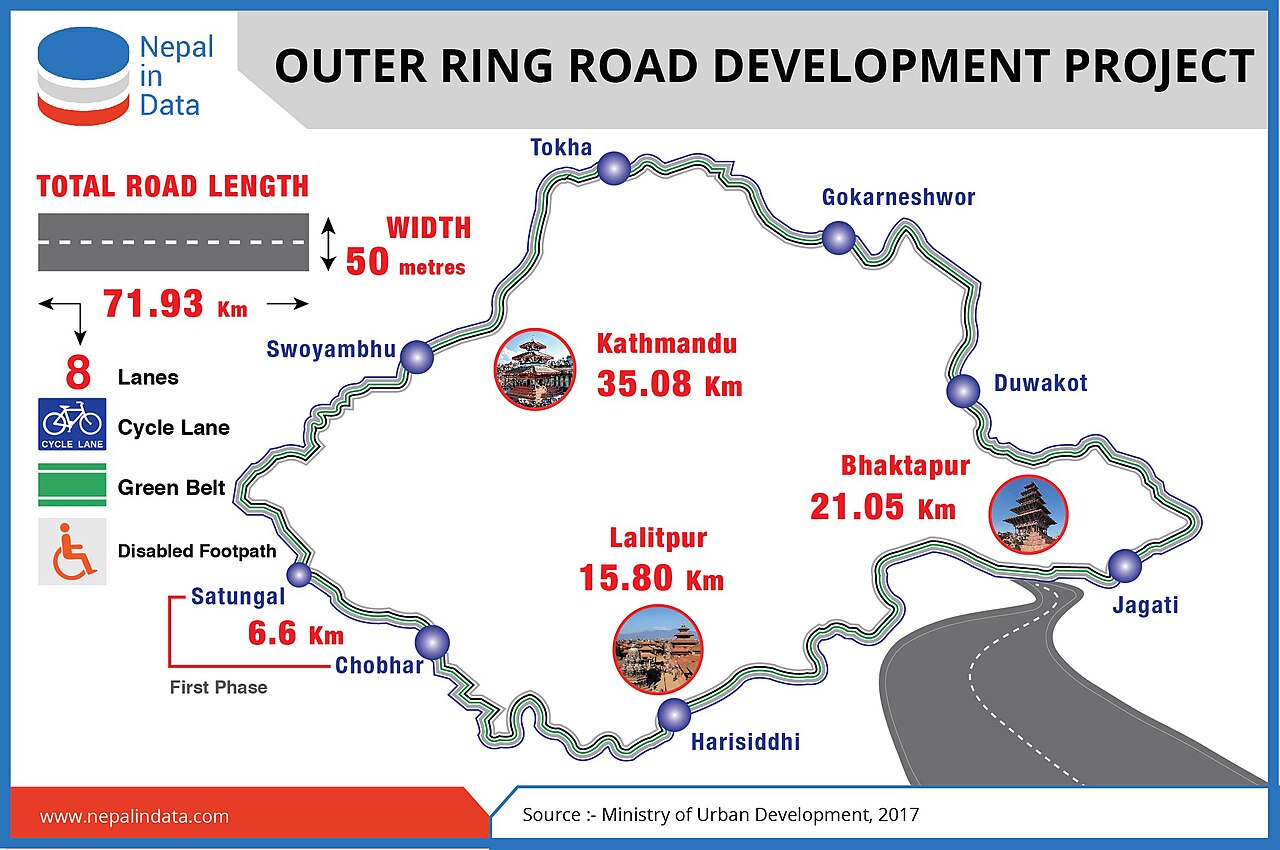
English: Outer Ring Road |
| Date | |
| Source | https://nepalindata.com/insight/outer-ring-road-development-project/ |
| Author | Ministry of urban development |
| Camera location | | View this and other nearby images on: OpenStreetMap |
|---|
Licensing
[edit]
This file is licensed under the Creative Commons Attribution 4.0 International license.
- You are free:
- to share – to copy, distribute and transmit the work
- to remix – to adapt the work
- Under the following conditions:
- attribution – You must give appropriate credit, provide a link to the license, and indicate if changes were made. You may do so in any reasonable manner, but not in any way that suggests the licensor endorses you or your use.
File history
Click on a date/time to view the file as it appeared at that time.
| Date/Time | Thumbnail | Dimensions | User | Comment | |
|---|---|---|---|---|---|
| current | 13:07, 12 July 2024 | | 2,341 × 1,554 (373 KB) | Raju Babu (talk | contribs) | Uploaded a work by Ministry of urban development from https://nepalindata.com/insight/outer-ring-road-development-project/ with UploadWizard |
You cannot overwrite this file.
File usage on Commons
The following page uses this file:
File usage on other wikis
The following other wikis use this file:
- Usage on en.wikipedia.org
- Usage on ne.wikipedia.org