File:Quantifying a realistic, worldwide wind and solar electricity supply - fig 2.png
Jump to navigation
Jump to search

Size of this preview: 600 × 599 pixels. Other resolutions: 240 × 240 pixels | 481 × 480 pixels | 677 × 676 pixels.
Original file (677 × 676 pixels, file size: 312 KB, MIME type: image/png)
Captions
Captions
Add a one-line explanation of what this file represents
Summary
[edit]
| Description |
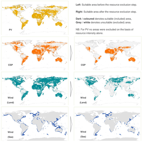
English: Figure Suitable area by technology. The suitable area on land and sea is found by successive exclusions for technical and economic reasons, using the resource intensity as a marker for economic viability. The figure shows available area before (left) and after (right) the resource exclusion step. From top to bottom: PV on land, CSP on land, Wind on land, Wind on sea. Dark/coloured denotes suitable area, grey/white denotes excluded area. of the article Quantifying a realistic, worldwide wind and solar electricity supply |
| Date | |
| Source | doi:10.1016/j.gloenvcha.2015.01.005 |
| Author | Yvonne Y. Denga, Martin Haighb, Willemijn Pouwelsc, Lou Ramaekersc, Ruut Brandsmac, Sven Schimschard, Jan Grözingerd, David de Jagerc |
| Permission (Reusing this file) |
English: You must give appropriate credit to the original work, together with a link to the formal publication through the relevant DOI and a link to the Creative Commons user license above. You must indicate if any changes are made but not in any way that suggests the licensor endorses you or your use of the work. |
Licensing
[edit]
This file is licensed under the Creative Commons Attribution 4.0 International license.
- You are free:
- to share – to copy, distribute and transmit the work
- to remix – to adapt the work
- Under the following conditions:
- attribution – You must give appropriate credit, provide a link to the license, and indicate if changes were made. You may do so in any reasonable manner, but not in any way that suggests the licensor endorses you or your use.
File history
Click on a date/time to view the file as it appeared at that time.
| Date/Time | Thumbnail | Dimensions | User | Comment | |
|---|---|---|---|---|---|
| current | 22:04, 22 October 2015 | | 677 × 676 (312 KB) | Alkab (talk | contribs) | == {{int:filedesc}} == {{Information |Description={{en|Figure ''Suitable area by technology. The suitable area on land and sea is found by successive exclusions for technical and economic reasons, using the resource intensity as a marker for economic v... |
You cannot overwrite this file.
File usage on Commons
The following page uses this file:
File usage on other wikis
The following other wikis use this file:
- Usage on en.wikisource.org