File:Quebec-00005 - Tower 2.jpg

Original file (4,211 × 6,140 pixels, file size: 15.27 MB, MIME type: image/jpeg)
Captions
Captions
Summary
[edit]
| Description |
English: PLEASE, NO invitations, graphics or self promotions, THEY WILL BE DELETED. My photos are FREE to use, just give me credit and it would be nice if you let me know, thanks.
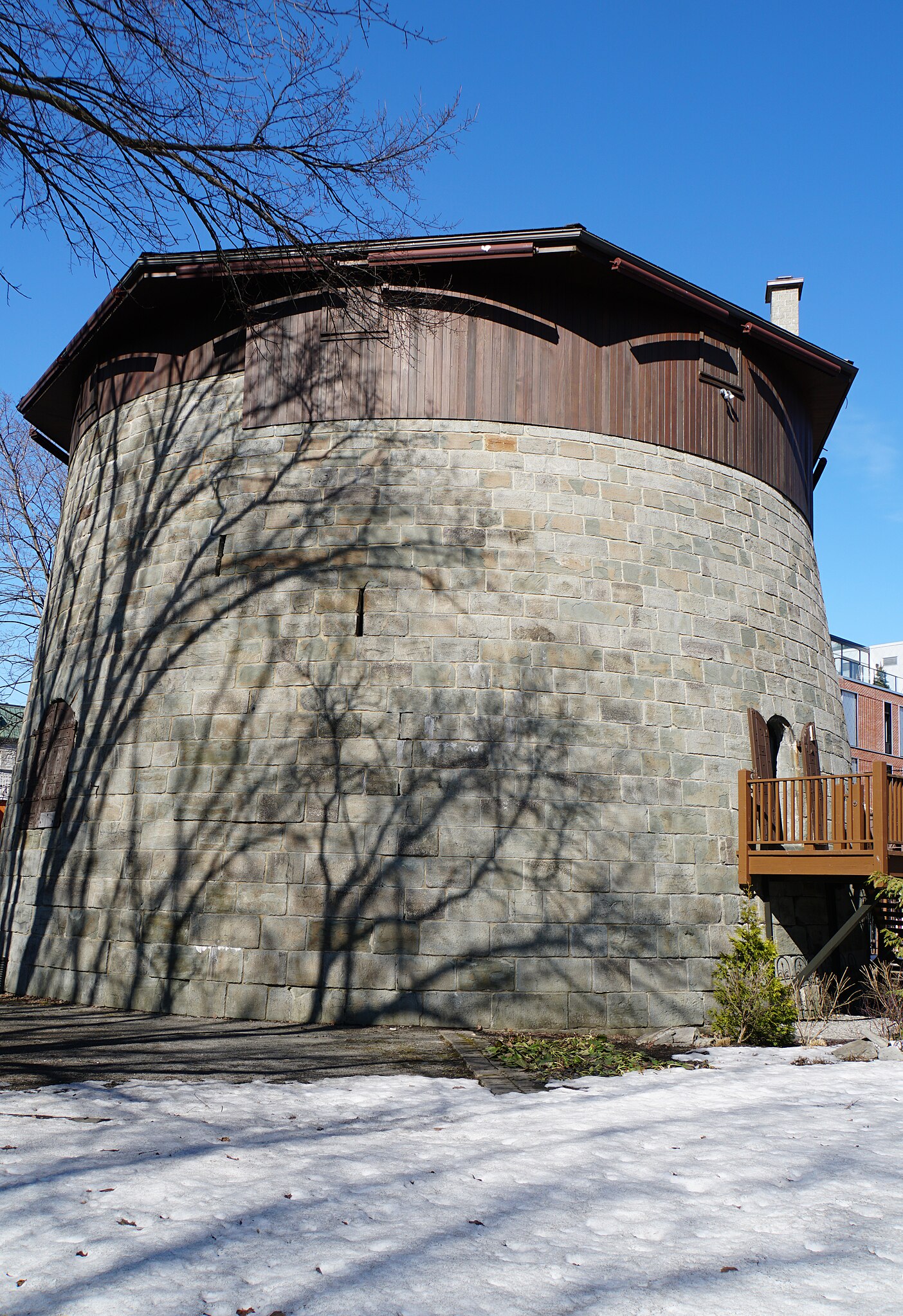
In the early 19th century, the British feared that the Americans, after gaining their independence (1776), would attempt to annex Upper and Lower Canada. In response to this threat Gother Mann, as commanding officer of the Royal Engineerings in Canada (1785-1804), urged the building of towers at Quebec to prevent an invader from approaching the existing fortifications. Ralph Bruyeres, Mann’s successor, began construction of four towers in the summer of 1808. James Craig, who was then the governor of the colony, ordered the work to go ahead without consent from the authorities in London, whom he presented with a “fait accomplished”. By 1812, when war began, the towers were completed and ready for service. They stand almost parallel to the wall over the entire width of the promontory, ensuring each other’s defence. They were not identified with names but numbers. Tower 1 overlooks the river on the Plains of Abraham; tower 2 is located ant the intersection of Cache and Wilfrid-Laurier streets; tower 3, located at the intersection of Rene-Levesque boulevard and Claire-Fontaine street, was torn down in 1905; tower 4 is located on Lavigueur street in the Saint-Jean-Baptiste district. Health Update: Radiation treatments were not that bad but after they were over I have been extremely tired but not sleepy. I am gaining strength every day and went to the gym for the first time since the treatments, did 10 minutes on a treadmill. |
| Date | |
| Source | https://www.flickr.com/photos/archer10/53047707556/ |
| Author | Dennis Jarvis |
| Camera location | | View this and other nearby images on: OpenStreetMap |
|---|
Licensing
[edit]
- You are free:
- to share – to copy, distribute and transmit the work
- to remix – to adapt the work
- Under the following conditions:
- attribution – You must give appropriate credit, provide a link to the license, and indicate if changes were made. You may do so in any reasonable manner, but not in any way that suggests the licensor endorses you or your use.
- share alike – If you remix, transform, or build upon the material, you must distribute your contributions under the same or compatible license as the original.
| This image was originally posted to Flickr by archer10 (Dennis) at https://flickr.com/photos/22490717@N02/53047707556. It was reviewed on 23 December 2023 by FlickreviewR 2 and was confirmed to be licensed under the terms of the cc-by-sa-2.0. |
File history
Click on a date/time to view the file as it appeared at that time.
| Date/Time | Thumbnail | Dimensions | User | Comment | |
|---|---|---|---|---|---|
| current | 12:04, 23 December 2023 | | 4,211 × 6,140 (15.27 MB) | Syrus257 (talk | contribs) | Uploaded a work by Dennis Jarvis from https://www.flickr.com/photos/archer10/53047707556/ with UploadWizard |
You cannot overwrite this file.
File usage on Commons
There are no pages that use this file.