File:Quebec province gazoduq.svg
Jump to navigation
Jump to search

Size of this PNG preview of this SVG file: 800 × 514 pixels. Other resolutions: 320 × 206 pixels | 640 × 411 pixels | 1,024 × 658 pixels | 1,280 × 823 pixels | 2,560 × 1,646 pixels | 910 × 585 pixels.
Original file (SVG file, nominally 910 × 585 pixels, file size: 934 KB)
Captions
Captions
Add a one-line explanation of what this file represents
Summary
[edit]
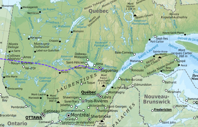
| Description |
Français : Carte approximative du tracé du projet Gazoduq topographique en français du Québec, Canada, avec agglomérations suivant le recensement de 2000.
Note : Le fond de carte est une image bitmap embarquée dans le fichier SVG. Lambert conformal conic projection; NAD83 datum ;
First standard parallel: 46° N
Second standard parallel: 60° N
Central meridian: 068° 30' W
Origin latitude: 44° N
Scales: bathymetry: 1:7,750,000 – topography: 1:5,600,000 |
| Date | |
| Source |
Own work ; base map is a derivative from Eric Gaba's Image:Quebec province topographic map-fr.svg
|
| Author | User:Eshko Timiou |
Licensing
[edit]
This file is licensed under the Creative Commons Attribution-Share Alike 4.0 International license.
- You are free:
- to share – to copy, distribute and transmit the work
- to remix – to adapt the work
- Under the following conditions:
- attribution – You must give appropriate credit, provide a link to the license, and indicate if changes were made. You may do so in any reasonable manner, but not in any way that suggests the licensor endorses you or your use.
- share alike – If you remix, transform, or build upon the material, you must distribute your contributions under the same or compatible license as the original.
File history
Click on a date/time to view the file as it appeared at that time.
| Date/Time | Thumbnail | Dimensions | User | Comment | |
|---|---|---|---|---|---|
| current | 23:16, 10 March 2020 | | 910 × 585 (934 KB) | Eshko Timiou (talk | contribs) | Uploaded a work by User:Eshko Timiou from Own work ; base map is a derivative from Eric Gaba's Image:Quebec province topographic map-fr.svg<br/> *Sources of data:<br/> **NASA SRTM30 (public domain);<br/> **NGDC ETOPO1 (public domain);<br/> **NGDC World Data Bank II (public domain);<br/> **NGDC GSHHS (public domain);<br/> **National Atlas of the United States of America (public domain);<br/> **Boundaries: Canadian [http://www.geobase.ca/geobase/fr/index.html GéoBase];<br/>... |
You cannot overwrite this file.
File usage on Commons
There are no pages that use this file.
File usage on other wikis
The following other wikis use this file:
- Usage on fr.wikipedia.org
- Usage on tr.wikipedia.org