File:Réseau Citura 2013.png
Jump to navigation
Jump to search
Size of this preview: 732 × 600 pixels. Other resolutions: 293 × 240 pixels | 586 × 480 pixels | 937 × 768 pixels | 1,249 × 1,024 pixels | 2,499 × 2,048 pixels | 4,612 × 3,780 pixels.
Original file (4,612 × 3,780 pixels, file size: 15.85 MB, MIME type: image/png)
Captions
Captions
Add a one-line explanation of what this file represents
Summary
[edit]
| Description |
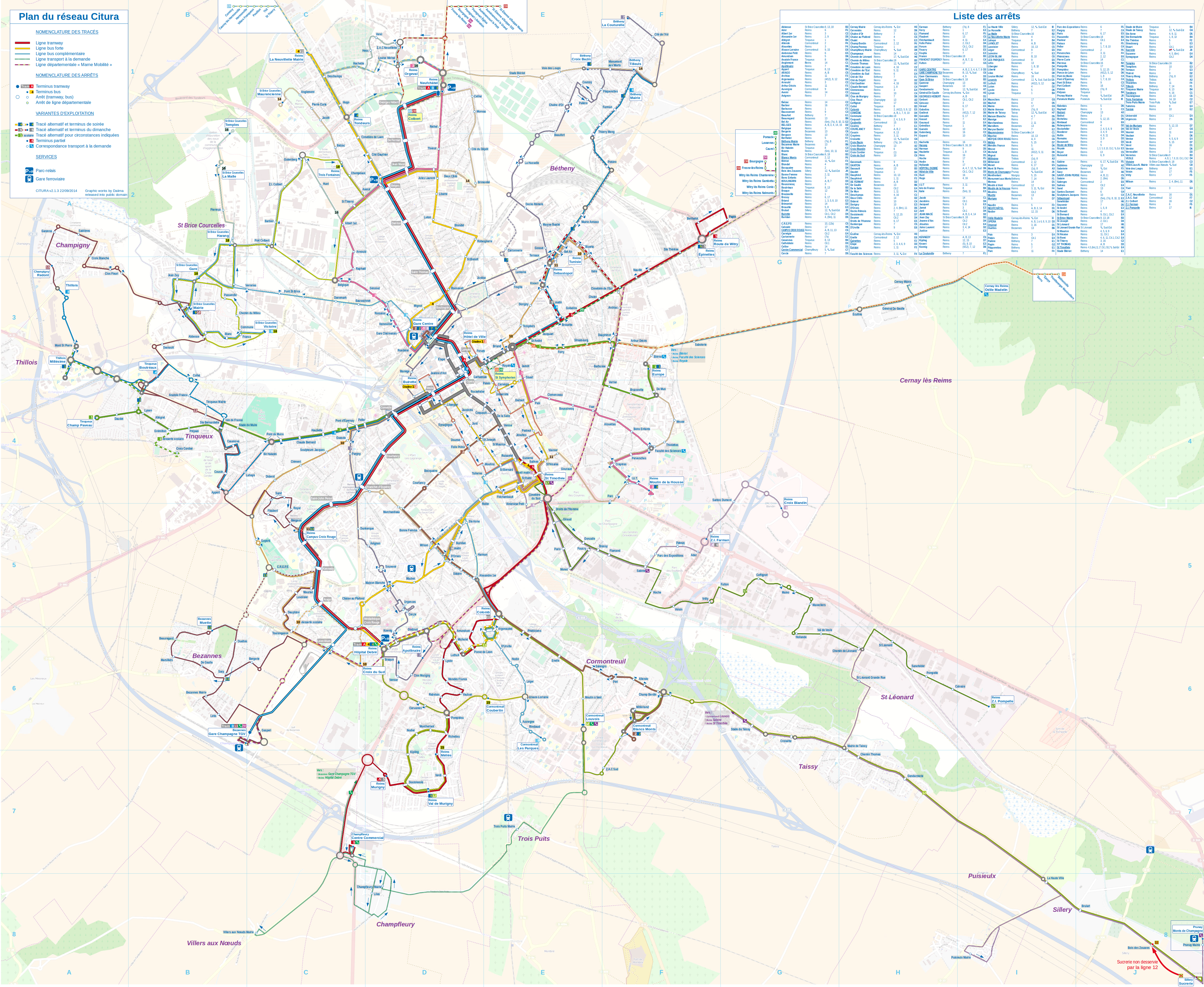
Français : Plan du réseau Citura, recréé à l'occasion des extensions de 2013. Réseau de soirée intégré. English: Map of Citura bus & tram network. (Reims, France) File created with free materials and softwares only: OpenStreetMap background, Liberation Sans family and OpenSymobol typefaces, a DoT train icon, generated with LibreOffice suite and the Gimp. |
| Date | |
| Source | Own work |
| Author | Daiima |
| Carte précédente Previous map |
Carte actuelle This map |
Carte suivante Next map |
| Image:CituraReseau2011.png | Image:Réseau Citura 2013.png | |
| 2011-2013 | 2013 | (dernière - last) |
Licensing
[edit]
I, the copyright holder of this work, hereby publish it under the following license:
| This file is made available under the Creative Commons CC0 1.0 Universal Public Domain Dedication. | |
| The person who associated a work with this deed has dedicated the work to the public domain by waiving all of their rights to the work worldwide under copyright law, including all related and neighboring rights, to the extent allowed by law. You can copy, modify, distribute and perform the work, even for commercial purposes, all without asking permission.
|
File history
Click on a date/time to view the file as it appeared at that time.
| Date/Time | Thumbnail | Dimensions | User | Comment | |
|---|---|---|---|---|---|
| current | 11:51, 22 September 2014 | | 4,612 × 3,780 (15.85 MB) | Daiima (talk | contribs) | màj tàd champfleury & st léonard |
| 10:55, 15 August 2014 |  | 4,612 × 3,780 (12.59 MB) | Daiima (talk | contribs) | Lignes départementales | |
| 18:18, 21 April 2014 |  | 781 × 640 (646 KB) | Daiima (talk | contribs) | Sillery Sucrerie non desservi par 12 | |
| 12:44, 25 March 2014 |  | 4,612 × 3,780 (9.7 MB) | Daiima (talk | contribs) | Romains | |
| 09:58, 22 March 2014 |  | 4,612 × 3,780 (9.7 MB) | Daiima (talk | contribs) | Pont de St Brice | |
| 21:15, 28 January 2014 |  | 4,612 × 3,780 (9.7 MB) | Daiima (talk | contribs) | sens circulation de la 13s dans Bezannes | |
| 11:55, 11 January 2014 |  | 4,612 × 3,780 (9.7 MB) | Daiima (talk | contribs) | Ligne 10 | |
| 19:05, 6 December 2013 |  | 4,612 × 3,780 (9.69 MB) | Daiima (talk | contribs) | Arrêt Barbier unidirectionnel Correction graphique de l'index des arrêts | |
| 16:36, 2 November 2013 |  | 4,612 × 3,780 (12.55 MB) | Daiima (talk | contribs) | corrected corrupted file | |
| 16:29, 2 November 2013 |  | 781 × 640 (689 KB) | Daiima (talk | contribs) | Pierreux stop on line 16 |
You cannot overwrite this file.
File usage on Commons
There are no pages that use this file.
File usage on other wikis
The following other wikis use this file:
- Usage on fr.wikipedia.org
- Usage on fr.wikivoyage.org
- Usage on it.wikivoyage.org
- Usage on pl.wikivoyage.org