File:RAF sketch map of the Qatar Peninsula.jpg
Jump to navigation
Jump to search

Size of this preview: 395 × 600 pixels. Other resolutions: 158 × 240 pixels | 316 × 480 pixels | 506 × 768 pixels | 674 × 1,024 pixels | 1,976 × 3,000 pixels.
Original file (1,976 × 3,000 pixels, file size: 778 KB, MIME type: image/jpeg)
Captions
Captions
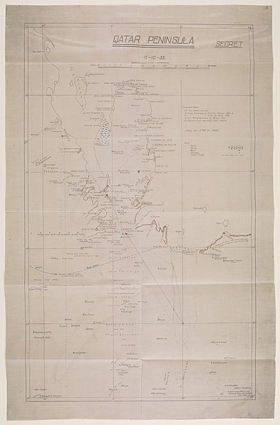
Map showing the Qatar Peninsula, dated to 1935.
Summary[edit]
| Description |
English: "Map showing the Qatar Peninsula and central part of the Eastern Province Saudi Arabia. Numerous notations concerning terrain features cover the face of the map with routes, the location of wells with good water, and sandy and marshy areas marked." |
| Date | |
| Source | Qatar Digital Library |
| Author | Aprim Bet-Benjamin of the A.H.Q. [Air Headquarters] Drawing Office |
| Other versions |

_-_Shagra.jpg)
Licensing[edit]
_(St_Edwards_Crown).svg)
|
This file is licensed under the Open Government Licence version 1.0 (OGL v1.0).
|
|---|---|
| Attribution:2 | |
|
You are free to:
See the Open Government Licence page on Meta-Wiki for more information.
|
File history
Click on a date/time to view the file as it appeared at that time.
| Date/Time | Thumbnail | Dimensions | User | Comment | |
|---|---|---|---|---|---|
| current | 02:27, 14 January 2019 | | 1,976 × 3,000 (778 KB) | Elspamo4 (talk | contribs) | User created page with UploadWizard |
You cannot overwrite this file.
File usage on Commons
The following 2 pages use this file: