File:RCEP.png
跳至導覽
跳至搜尋
預覽大小:600 × 599 像素。 其他解析度:240 × 240 像素 | 480 × 480 像素 | 769 × 768 像素 | 1,025 × 1,024 像素 | 2,050 × 2,048 像素 | 4,206 × 4,202 像素。
原始檔案 (4,206 × 4,202 像素,檔案大小:616 KB,MIME 類型:image/png)
說明
說明
添加單行說明來描述出檔案所代表的內容
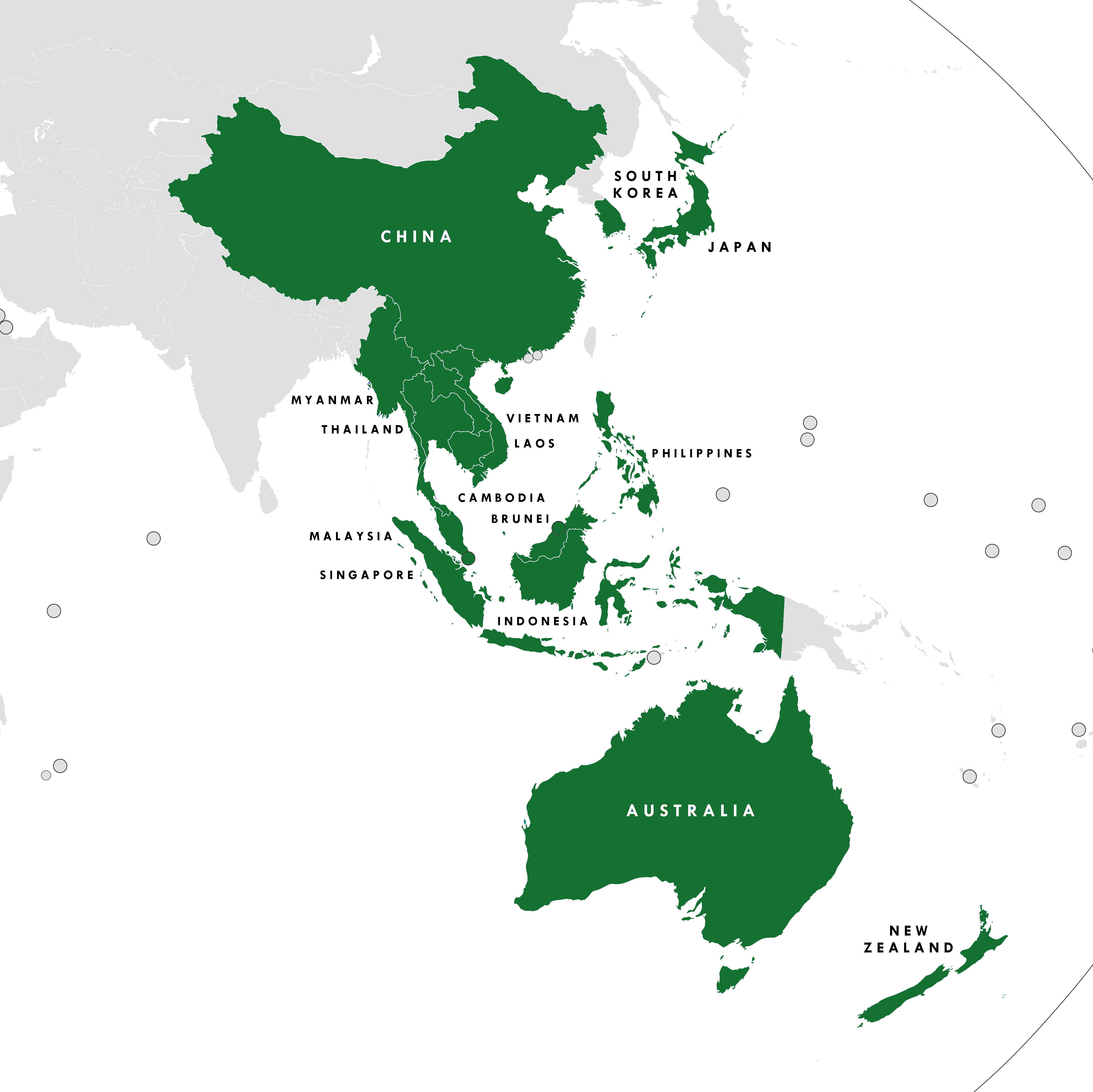
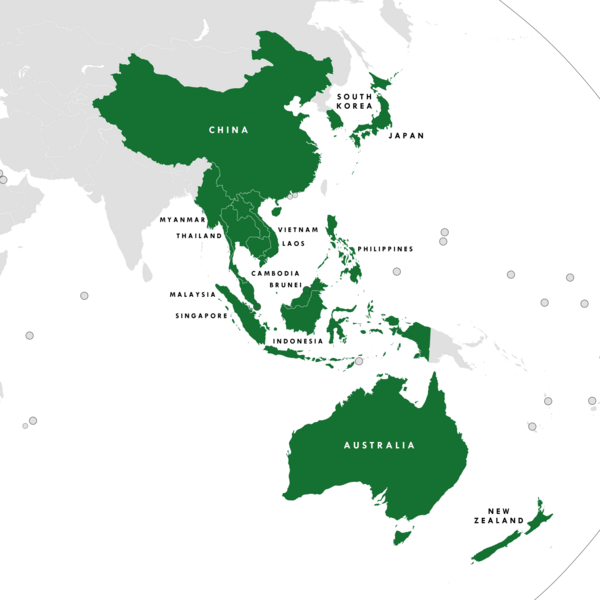
RCEP

|
本圖片是以PNG、GIF或JPEG格式上傳。然而,其中包含的資料或訊息,應該重新建立成可縮放向量圖形(SVG)檔案,以更有效率或更準確的方式儲存。如有可能,請上傳本圖片的SVG格式版本。在上傳之後,請修改維基各姊妹計畫中所有使用舊版圖片的條目(列在圖像連結章節中),替換為新版圖片,並在舊圖片的描述頁中加入{{Vector version available|新圖片名稱.svg}}模板,同時移除本模板。
|
摘要
[編輯]
| 描述 |
English: The members of the Regional Comprehensive Economic Partnership |
| 日期 | |
| 來源 | 自己的作品 |
| 作者 | Tiger 7253 |
| 其他版本 |
中文(简体):File:RCEP Chinese Map.png |
授權條款
[編輯]
我,本作品的著作權持有者,決定用以下授權條款發佈本作品:
此檔案採用創用CC 姓名標示-相同方式分享 4.0 國際授權條款。
- 您可以自由:
- 分享 – 複製、發佈和傳播本作品
- 重新修改 – 創作演繹作品
- 惟需遵照下列條件:
- 姓名標示 – 您必須指名出正確的製作者,和提供授權條款的連結,以及表示是否有對內容上做出變更。您可以用任何合理的方式來行動,但不得以任何方式表明授權條款是對您許可或是由您所使用。
- 相同方式分享 – 如果您利用本素材進行再混合、轉換或創作,您必須基於如同原先的相同或兼容的條款,來分布您的貢獻成品。
檔案歷史
點選日期/時間以檢視該時間的檔案版本。
| 日期/時間 | 縮圖 | 尺寸 | 使用者 | 備註 | |
|---|---|---|---|---|---|
| 目前 | 2023年7月16日 (日) 14:52 | | 4,206 × 4,202(616 KB) | Mike Rohsopht(留言 | 貢獻) | HK and MO are not members |
| 2023年4月2日 (日) 09:05 |  | 4,206 × 4,202(631 KB) | Kwamikagami(留言 | 貢獻) | rm. non-countries | |
| 2022年2月9日 (三) 06:43 |  | 4,206 × 4,202(634 KB) | Lukas Abelshauser(留言 | 貢獻) | Standardized color sheme for all RCEP members since it went in effect on 1 January 2022 | |
| 2020年1月2日 (四) 21:51 |  | 4,206 × 4,202(648 KB) | Tiger7253(留言 | 貢獻) | Minor corrections - Australian and NZ external territories, HK and Macau in a lighter shade of purple to signify PRC suzerainty | |
| 2020年1月1日 (三) 06:10 |  | 4,206 × 4,202(640 KB) | Afrogindahood(留言 | 貢獻) | Changed the color of ASEAN Plus Six countries (Australia & New Zealand) from cobalt blue to teal for better contrast | |
| 2019年12月30日 (一) 09:24 |  | 4,206 × 4,202(648 KB) | Tiger7253(留言 | 貢獻) | Reverted to version as of 17:34, 4 November 2019 (UTC) The previous colour scheme was standardised to be varying shades of blue/teal/purple. Please do not change it without a valid reason | |
| 2019年12月22日 (日) 00:24 |  | 4,206 × 4,202(658 KB) | Afrogindahood(留言 | 貢獻) | Changed the color of ASEAN Plus Three countries (China, Japan & South Korea) to bright purple and ASEAN Plus Six countries (Australia & New Zealand) to pink | |
| 2019年12月22日 (日) 00:09 |  | 4,206 × 4,202(635 KB) | Afrogindahood(留言 | 貢獻) | Addition of India | |
| 2019年11月4日 (一) 17:34 |  | 4,206 × 4,202(648 KB) | Tiger7253(留言 | 貢獻) | Updating the image to reflect India's departure from RCEP. | |
| 2019年11月4日 (一) 16:57 |  | 4,206 × 4,202(646 KB) | The Account 1(留言 | 貢獻) | Reverted to version as of 01:11, 3 April 2019 (UTC) These are the correct borders |
無法覆蓋此檔案。
檔案用途
全域檔案使用狀況
以下其他 wiki 使用了這個檔案:
- ar.wikipedia.org 的使用狀況
- cs.wikipedia.org 的使用狀況
- da.wikipedia.org 的使用狀況
- de.wikipedia.org 的使用狀況
- en.wikipedia.org 的使用狀況
- es.wikipedia.org 的使用狀況
- fa.wikipedia.org 的使用狀況
- fi.wikipedia.org 的使用狀況
- fr.wikipedia.org 的使用狀況
- he.wikipedia.org 的使用狀況
- hi.wikipedia.org 的使用狀況
- id.wikipedia.org 的使用狀況
- it.wikipedia.org 的使用狀況
- kn.wikipedia.org 的使用狀況
- ko.wikipedia.org 的使用狀況
- lt.wikipedia.org 的使用狀況
- ml.wikipedia.org 的使用狀況
- ms.wikipedia.org 的使用狀況
- my.wikipedia.org 的使用狀況
- nl.wikipedia.org 的使用狀況
- no.wikipedia.org 的使用狀況
- pl.wikipedia.org 的使用狀況
- pt.wikipedia.org 的使用狀況
- ta.wikipedia.org 的使用狀況
- th.wikipedia.org 的使用狀況
- uk.wikipedia.org 的使用狀況
- vi.wikipedia.org 的使用狀況
- www.wikidata.org 的使用狀況
- zh.wikipedia.org 的使用狀況
詮釋資料
分類:
- Association of Southeast Asian Nations
- International relations maps of Australia
- Asia-Pacific
- International relations maps of China
- International relations maps of Indonesia
- International relations maps of Japan
- International relations maps of Singapore
- Regional Comprehensive Economic Partnership
- Free trade agreement maps
- Maps of Oceania and Maritime Southeast Asia