File:RMF Atualmente.PNG
Jump to navigation
Jump to search
Size of this preview: 621 × 599 pixels. Other resolutions: 249 × 240 pixels | 497 × 480 pixels | 796 × 768 pixels | 1,061 × 1,024 pixels | 1,841 × 1,777 pixels.
Original file (1,841 × 1,777 pixels, file size: 199 KB, MIME type: image/png)
Captions
Captions
Add a one-line explanation of what this file represents
Summary
[edit]
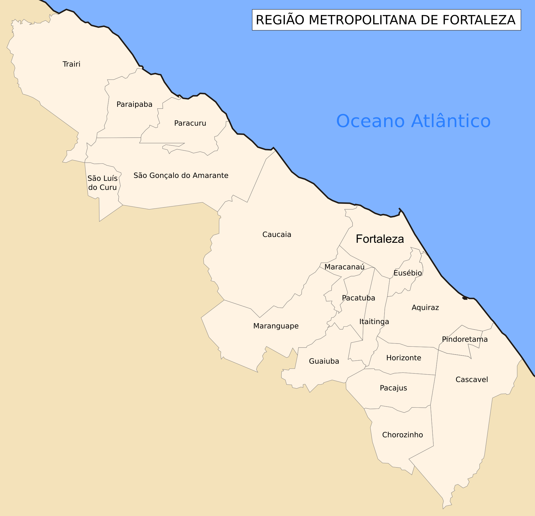
| Description | Mapa político administrativo dos municípios da Região Metropolitana de Fortaleza - Brasil |
| Date | 6 April 2006 (original upload date) |
| Source | No machine-readable source provided. Own work assumed (based on copyright claims). |
| Author | No machine-readable author provided. Davidandrade assumed (based on copyright claims). |
Licensing
[edit]
| I, the copyright holder of this work, release this work into the public domain. This applies worldwide. In some countries this may not be legally possible; if so: I grant anyone the right to use this work for any purpose, without any conditions, unless such conditions are required by law. |
File history
Click on a date/time to view the file as it appeared at that time.
| Date/Time | Thumbnail | Dimensions | User | Comment | |
|---|---|---|---|---|---|
| current | 19:03, 19 June 2015 | | 1,841 × 1,777 (199 KB) | Marquinhos (talk | contribs) | Municípios incluídos em 2014. |
| 05:17, 23 December 2009 |  | 783 × 599 (29 KB) | Davidandrade (talk | contribs) | novos municípios | |
| 06:56, 23 September 2007 |  | 783 × 599 (28 KB) | Davidandrade (talk | contribs) | ||
| 03:13, 6 April 2006 |  | 791 × 605 (20 KB) | Davidandrade (talk | contribs) | Mapa político administrativo dos municípios da Região Metropolitana de Fortaleza - Brasil |
You cannot overwrite this file.
File usage on Commons
The following page uses this file:
File usage on other wikis
The following other wikis use this file:
- Usage on fr.wikipedia.org
- Usage on it.wikipedia.org
- Usage on pt.wikipedia.org
- Fortaleza
- Pacatuba (Ceará)
- Horizonte (Ceará)
- Aquiraz
- Caucaia
- Guaiúba (Ceará)
- Itaitinga
- Maracanaú
- Maranguape
- Pacajus
- Paracuru
- Paraipaba
- Pindoretama
- São Luís do Curu
- Trairi
- Eusébio (Ceará)
- São Gonçalo do Amarante (Ceará)
- Região Metropolitana de Fortaleza
- Predefinição:Região Metropolitana de Fortaleza
- Wikipédia Discussão:Projetos/Subdivisões do Brasil/Arquivo/Modelos de navegação/I
- Usuário:Joelkaula/Ceará
- Usage on pt.wikivoyage.org
- Usage on ru.wikipedia.org
- Usage on sv.wikipedia.org