File:RS 1993.png
Jump to navigation
Jump to search

Size of this preview: 631 × 600 pixels. Other resolutions: 252 × 240 pixels | 505 × 480 pixels | 808 × 768 pixels | 1,077 × 1,024 pixels | 1,506 × 1,432 pixels.
Original file (1,506 × 1,432 pixels, file size: 37 KB, MIME type: image/png)
Captions
Captions
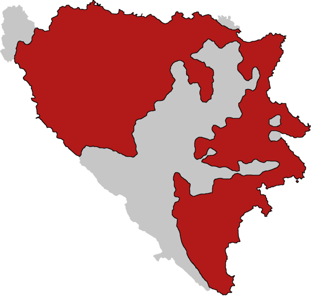
Republika Srpska in early 1993
Summary
[edit]
| Description |
English: Territory controlled by Republika Srpska at the time of Vance-Owen Plan. Done according to the map presented by General Mladic during National Assembly session in May 1993 |
| Date | |
| Source | Own work |
| Author | SRofSerbia |
Licensing
[edit]
| This map is ineligible for copyright and therefore in the public domain, because it consists entirely of information that is common property and contains no original authorship. For more information, see Commons:Threshold of originality § Maps.
|
File history
Click on a date/time to view the file as it appeared at that time.
| Date/Time | Thumbnail | Dimensions | User | Comment | |
|---|---|---|---|---|---|
| current | 17:26, 17 November 2022 | | 1,506 × 1,432 (37 KB) | SRofSrb (talk | contribs) | Uploaded own work with UploadWizard |
You cannot overwrite this file.
File usage on Commons
The following page uses this file:
File usage on other wikis
The following other wikis use this file:
- Usage on bs.wikipedia.org
- Usage on en.wikipedia.org
- Usage on es.wikipedia.org
- Usage on sr.wikipedia.org
- Usage on th.wikipedia.org