File:Ranks of countries by the Good Country Index 1.5 (2020).png
跳至導覽
跳至搜尋

預覽大小:800 × 441 像素。 其他解析度:320 × 176 像素 | 640 × 353 像素 | 1,024 × 564 像素 | 1,280 × 705 像素 | 2,560 × 1,411 像素 | 7,192 × 3,964 像素。
原始檔案 (7,192 × 3,964 像素,檔案大小:1.92 MB,MIME 類型:image/png)
說明
說明
添加單行說明來描述出檔案所代表的內容
摘要
[編輯].png&action=edit§ion=1)
| 描述 |
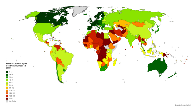
English: A colour-coded map showing countries as ranked by the Version 1.5 of the Good Country Index (2020), on a gradient scale from green to red. |
| 日期 | |
| 來源 | 自己的作品 |
| 作者 | Asus2004 |
授權條款
[編輯].png&action=edit§ion=2)
| This map was created for free at MapChart.net. All maps created there are licensed under the Creative Commons Attribution-ShareAlike 4.0 International License. See the "Licensing" link on the home page, or the MapChart.net feedback page for the image license info, and this MapChart.net Commons discussion. Use {{Mapchart.net}} to provide attribution for maps created with that service.
See also: Other maps on Commons created with Mapchart.net: Category:Mapchart.net and this search query; other map and chart resources. |
我,本作品的著作權持有者,決定用以下授權條款發佈本作品:
此檔案採用共享創意 姓名標示-相同方式分享 4.0 國際授權條款。
- 您可以自由:
- 分享 – 複製、發佈和傳播本作品
- 重新修改 – 創作演繹作品
- 惟需遵照下列條件:
- 姓名標示 – 您必須指名出正確的製作者,和提供授權條款的連結,以及表示是否有對內容上做出變更。您可以用任何合理的方式來行動,但不得以任何方式表明授權條款是對您許可或是由您所使用。
- 相同方式分享 – 如果您利用本素材進行再混合、轉換或創作,您必須基於如同原先的相同或兼容的條款,來分布您的貢獻成品。
檔案歷史
點選日期/時間以檢視該時間的檔案版本。
| 日期/時間 | 縮圖 | 尺寸 | 用戶 | 備註 | |
|---|---|---|---|---|---|
| 目前 | 2022年9月24日 (六) 16:52 | | 7,192 × 3,964(1.92 MB) | Asus2004(對話 | 貢獻) | Reverted to version as of 16:47, 24 September 2022 (UTC) |
| 2022年9月24日 (六) 16:52 |  | 6,300 × 3,420(2 MB) | Asus2004(對話 | 貢獻) | Reverted to version as of 18:13, 18 August 2018 (UTC) | |
| 2022年9月24日 (六) 16:47 |  | 7,192 × 3,964(1.92 MB) | Asus2004(對話 | 貢獻) | Updated to Version 1.5 of the index | |
| 2018年8月18日 (六) 18:13 |  | 6,300 × 3,420(2 MB) | JackintheBox(對話 | 貢獻) | Changed < sign to > sign | |
| 2018年5月21日 (一) 01:54 |  | 6,300 × 3,420(2 MB) | JackintheBox(對話 | 貢獻) | User created page with UploadWizard |
無法覆蓋此檔案。
檔案用途
下列頁面有用到此檔案:
.png&redirect=no)
全域檔案使用狀況
以下其他 wiki 使用了這個檔案:
- ar.wikipedia.org 的使用狀況
- ca.wikipedia.org 的使用狀況
- en.wikipedia.org 的使用狀況
- fa.wikipedia.org 的使用狀況
- fr.wikipedia.org 的使用狀況
- it.wikipedia.org 的使用狀況
- ko.wikipedia.org 的使用狀況
- si.wikipedia.org 的使用狀況
- tr.wikipedia.org 的使用狀況
- uk.wikipedia.org 的使用狀況
- vi.wikipedia.org 的使用狀況
- zh.wikipedia.org 的使用狀況
.png&oldid=691406892)