File:Rear of Corpus Christi Hall, Maidstone.jpg
Jump to navigation
Jump to search

Size of this preview: 402 × 599 pixels. Other resolutions: 161 × 240 pixels | 322 × 480 pixels | 515 × 768 pixels | 1,088 × 1,621 pixels.
Original file (1,088 × 1,621 pixels, file size: 303 KB, MIME type: image/jpeg)
Captions
Captions
Add a one-line explanation of what this file represents
Summary
[edit]
| Description |
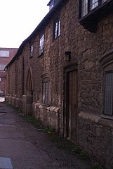
English: Rear of Corpus Christi Hall, Maidstone |
| Date | |
| Source |
This file was derived from: Alleyway off Earl Street, Maidstone (geograph 3401038).jpg |
| Author | Danny Robinson |
| Permission (Reusing this file) |
Creative Commons Attribution Share-alike license 2.0 |
| Attribution (required by the license) | Danny P Robinson / Alleyway off Earl Street, Maidstone / |
.jpg)
| Camera location | | View this and other nearby images on: OpenStreetMap |
|---|
Licensing
[edit]
This file is licensed under the Creative Commons Attribution-Share Alike 2.0 Generic license.
Attribution: Danny Robinson
- You are free:
- to share – to copy, distribute and transmit the work
- to remix – to adapt the work
- Under the following conditions:
- attribution – You must give appropriate credit, provide a link to the license, and indicate if changes were made. You may do so in any reasonable manner, but not in any way that suggests the licensor endorses you or your use.
- share alike – If you remix, transform, or build upon the material, you must distribute your contributions under the same or compatible license as the original.
File history
Click on a date/time to view the file as it appeared at that time.
| Date/Time | Thumbnail | Dimensions | User | Comment | |
|---|---|---|---|---|---|
| current | 14:30, 29 June 2018 | | 1,088 × 1,621 (303 KB) | Bjh21 (talk | contribs) | Re-crop from higher-resolution original: File:Alleyway off Earl Street, Maidstone (geograph 3401038).jpg cropped 58 % horizontally, 6 % vertically, rotated 4° using CropTool with precise mode. |
| 00:14, 26 October 2014 |  | 272 × 405 (61 KB) | DavidCane (talk | contribs) | Rotate 4 degrees clockwise and crop | |
| 00:11, 26 October 2014 |  | 640 × 427 (76 KB) | DavidCane (talk | contribs) | == {{int:filedesc}} == {{Information |Description={{en|1=Rear of Corpus Christi Hall, Maidstone}} |Source=From [http://www.geograph.org.uk/photo/3401038 geograph.org.uk] |Date=2013-04-07 |Author=[http://www.geograph.org.uk/profile/5299 Danny Robinson]... |
You cannot overwrite this file.
File usage on Commons
The following 2 pages use this file:
File usage on other wikis
The following other wikis use this file:
- Usage on en.wikipedia.org
- Usage on www.wikidata.org