File:Record number of wildfires in Amazonas, Brazil.jpg

Original file (4,400 × 2,535 pixels, file size: 2.79 MB, MIME type: image/jpeg)
Captions
Captions
Summary
[edit]
| Description |
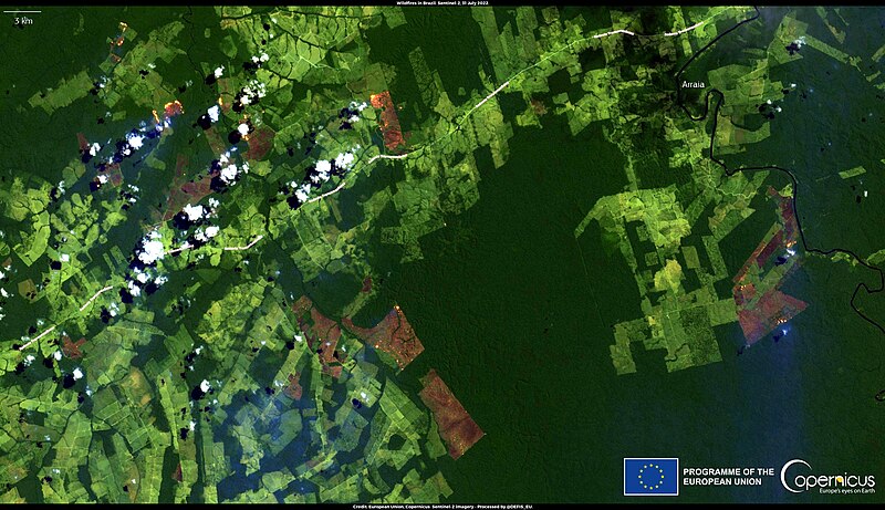
English: Brazil is currently affected by numerous fires burning down large portions of its territory. According to the National Institute for Space Research of Brazil (Instituto Nacional de Pesquisas Espaciais, INPE), the number of active hotspots detected in July 2022 in Amazonas, northern Brazil, was the third highest recorded since 2006. Moreover, the numerous blazes are producing smoke plumes that are engulfing the skies of part of the country and affecting air quality. This image, acquired by one of the Copernicus Sentinel-2 satellites on 31 July 2022, shows active fires – and the emitted smoke – close to Apuí, a municipality located in eastern Amazonas. The open data retrieved by Copernicus Sentinel satellites are an important source of valuable information related to wildfire events. For example, they are key for detecting active fires and assessing the damages caused. |
| Date | 2 August 2022 (upload date) |
| Source | Record number of wildfires in Amazonas, Brazil |
| Author | European Union, Copernicus Sentinel-2 imagery |
Licensing
[edit]

|
This image contains data from a satellite in the Copernicus Programme, such as Sentinel-1, Sentinel-2 or Sentinel-3. Attribution is required when using this image.
Attribution: Contains modified Copernicus Sentinel data 2022
The use of Copernicus Sentinel Data is regulated under EU law (Commission Delegated Regulation (EU) No 1159/2013 and Regulation (EU) No 377/2014). Relevant excerpts:
Free access shall be given to GMES dedicated data [...] made available through GMES dissemination platforms [...].
Access to GMES dedicated data [...] shall be given for the purpose of the following use in so far as it is lawful:
GMES dedicated data [...] may be used worldwide without limitations in time.
GMES dedicated data and GMES service information are provided to users without any express or implied warranty, including as regards quality and suitability for any purpose. |
File history
Click on a date/time to view the file as it appeared at that time.
| Date/Time | Thumbnail | Dimensions | User | Comment | |
|---|---|---|---|---|---|
| current | 11:32, 16 August 2023 | | 4,400 × 2,535 (2.79 MB) | OptimusPrimeBot (talk | contribs) | #Spacemedia - Upload of https://www.copernicus.eu/system/files/2022-08/image_day/20220802_WildfiresInBrazil.jpg via Commons:Spacemedia |
You cannot overwrite this file.
File usage on Commons
There are no pages that use this file.