File:RedArmy19Aug31Dec44.jpg
跳转到导航
跳转到搜索
本预览的尺寸:788 × 600像素。 其他分辨率:315 × 240像素 | 631 × 480像素 | 1,009 × 768像素 | 1,256 × 956像素。
原始文件 (1,256 × 956像素,文件大小:531 KB,MIME类型:image/jpeg)
说明
说明
添加一行文字以描述该文件所表现的内容
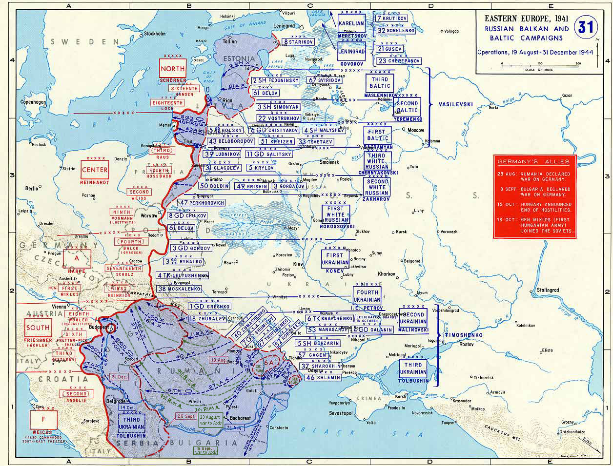
Taken from the campaign series, made public by the US-Army under www.dean.usma.edu The picture is public domain. It shows the situation of the Easter Front from 13. Aug. '44 until 31. Dec. '44
- Source: dean.usma.edu archive copy at the Wayback Machine
From website:
- In 1938 the predecessors of what is today The Department of History at the United States Military Academy began developing a series of campaign atlases to aid in teaching cadets a course entitled, "History of the Military Art." Since then, the Department has produced over six atlases and more than one thousand maps, encompassing not only America’s wars but global conflicts as well.
- In keeping abreast with today's technology, the Department of History is providing these maps on the internet as part of the department's outreach program. The maps were created by the United States Military Academy’s Department of History and are the digital versions from the atlases printed by the United States Defense Printing Agency. We gratefully acknowledge the accomplishments of the department's former cartographer, Mr. Edward J. Krasnoborski, along with the works of our present cartographer, Mr. Frank Martini.
- Please be aware that these maps are large in file size and may require substantial download times.
|
|
 |

|
此map图片可使用矢量图形重新创建为SVG文件。这具有很多好处;更多信息请参见共享资源:待清理媒体。如果存在此图片的SVG格式,请将其上传,然后将此模板替换为
{{vector version available|新图片名称}}。
建议您将SVG命名为“RedArmy19Aug31Dec44.svg”,这样在使用Vector version available(或Vva)模板时就不需要填写新图片名称参数。 |


文件历史
点击某个日期/时间查看对应时刻的文件。
| 日期/时间 | 缩略图 | 大小 | 用户 | 备注 | |
|---|---|---|---|---|---|
| 当前 | 2015年1月12日 (一) 18:47 | | 1,256 × 956(531 KB) | Spiridon Ion Cepleanu(留言 | 贡献) | Borders of years 1940-1944 (rectified some little mistakes) |
| 2007年4月22日 (日) 10:52 |  | 1,256 × 956(203 KB) | Nasiruddin(留言 | 贡献) | Taken from the campaign series, made public by the US-Army under www.dean.usma.edu The picture is public domain. It shows the situation of the Easter Front from 13. Aug. '44 until 31. Dec. '44 *Source: [http://www.dean.usma.edu/history/web03/atlases/grea |
您不可以覆盖此文件。
文件用途
没有页面使用本文件。
全域文件用途
以下其他wiki使用此文件:
- ar.wikipedia.org上的用途
- ca.wikipedia.org上的用途
- cs.wikipedia.org上的用途
- de.wikipedia.org上的用途
- el.wikipedia.org上的用途
- en.wikipedia.org上的用途
- es.wikipedia.org上的用途
- et.wikipedia.org上的用途
- fr.wikipedia.org上的用途
- he.wikipedia.org上的用途
- id.wikipedia.org上的用途
- it.wikipedia.org上的用途
- ja.wikipedia.org上的用途
- nl.wikipedia.org上的用途
- pl.wikipedia.org上的用途
- pnb.wikipedia.org上的用途
- ro.wikipedia.org上的用途
- ru.wikipedia.org上的用途
- sh.wikipedia.org上的用途
- sr.wikipedia.org上的用途
查看本文件的更多全域用途。