File:Red and Blue States Map (Average Margins of Presidential Victory).svg
ナビゲーションに移動
検索に移動

この SVG ファイルのこの PNG プレビューのサイズ: 800 × 495 ピクセル. その他の解像度: 320 × 198 ピクセル | 640 × 396 ピクセル | 1,024 × 633 ピクセル | 1,280 × 791 ピクセル | 2,560 × 1,583 ピクセル | 959 × 593 ピクセル。
元のファイル (SVG ファイル、959 × 593 ピクセル、ファイルサイズ: 68キロバイト)
キャプション
キャプション
このファイルの内容を1行で記述してください

| 解説 |
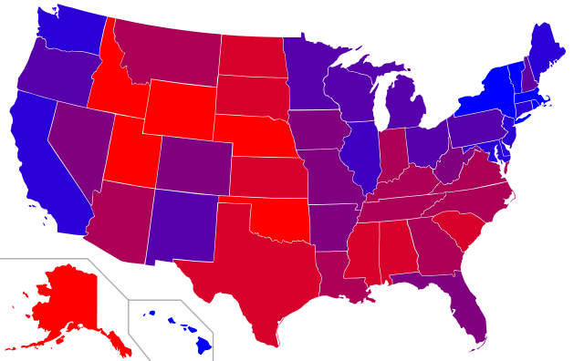
Map of red states and blue states in the U.S.
|
|
| 日付 | (UTC) | |
| 原典 | ||
| 作者 |
|
|
| その他のバージョン |
|

この作品の著作権者である私は、この作品を以下のライセンスで提供します。
| このファイルはクリエイティブ・コモンズ 表示-継承 3.0 非移植ライセンスのもとに利用を許諾されています。 | ||
| ||
| このライセンスのテンプレートは、GFDLのライセンス・アップデートによりこのファイルに追加されたものです。 |

|
この文書は、フリーソフトウェア財団発行のGNUフリー文書利用許諾書 (GNU Free Documentation License) 1.2またはそれ以降のバージョンの規約に基づき、複製や再配布、改変が許可されます。不可変更部分、表紙、背表紙はありません。このライセンスの複製は、GNUフリー文書利用許諾書という章に含まれています。 |
あなたは上記のライセンスから、どれか一つ以上を選択できます。
元のアップロードログ
[編集].svg&action=edit§ion=1)
This image is a derivative work of the following images:
- File:Blank_US_Map.svg licensed with Cc-by-sa-3.0-migrated, GFDL
- 2009-11-05T19:44:02Z NuclearVacuum 959x593 (91518 Bytes) minor fix from previous upload
- 2009-11-05T19:39:42Z NuclearVacuum 959x593 (88399 Bytes) Fixed up the borders so they are connected with each state and loosing that gap between them.
- 2008-10-09T16:36:40Z Howcheng 959x593 (80121 Bytes) Reverted to version as of 08:32, 14 June 2007
- 2008-03-12T00:20:02Z AMK1211 959x593 (174744 Bytes) Added borders: Light blue for water borders and black for land borders (international borders thicker).
- 2007-06-14T08:32:47Z Fibonacci 959x593 (80121 Bytes) Optimised code.
- 2006-07-12T23:00:30Z Theshibboleth 959x593 (90537 Bytes) The line framework around Alaska and Hawaii has been pushed a bit
- 2006-07-12T06:35:19Z Theshibboleth 959x593 (89828 Bytes) added DC
- 2006-07-12T06:05:05Z Theshibboleth 959x593 (89649 Bytes) {{Information |Description=A blank map of the United States in scalable vector form. |Source=Own work, based on [[:Image:Electorial map.svg]], inspired by [[:Image:BlankMap-World.png]] |Date=11 July 2006 |Author=[[User:Theshi
Uploaded with derivativeFX
ファイルの履歴
過去の版のファイルを表示するには、その版の日時をクリックしてください。
| 日付と時刻 | サムネイル | 寸法 | 利用者 | コメント | |
|---|---|---|---|---|---|
| 現在の版 | 2011年2月17日 (木) 17:58 | | 959 × 593 (68キロバイト) | Ninjatacoshell (トーク | 投稿記録) | Changed colors so they're more evenly distributed. |
| 2011年2月17日 (木) 17:15 |  | 959 × 593 (68キロバイト) | Ninjatacoshell (トーク | 投稿記録) | {{Information |Description=Map of red states and blue states in the U.S.<br><br> Key: The following classification of red and blue states (as well as purple/battleground states) was determined by compiling the average marg |
このファイルは上書きできません。
ファイルの使用状況
以下の 3 ページがこのファイルを使用しています:
グローバルなファイル使用状況
以下に挙げる他のウィキがこの画像を使っています:
- ko.wikipedia.org での使用状況
- ml.wikipedia.org での使用状況
- zh.wikipedia.org での使用状況
.svg&oldid=476255029)