File:Redväg Brunn.svg
Jump to navigation
Jump to search

Size of this PNG preview of this SVG file: 513 × 600 pixels. Other resolutions: 205 × 240 pixels | 411 × 480 pixels | 657 × 768 pixels | 876 × 1,024 pixels | 1,752 × 2,048 pixels | 4,198 × 4,906 pixels.
Original file (SVG file, nominally 4,198 × 4,906 pixels, file size: 432 KB)
Captions
Captions
Add a one-line explanation of what this file represents
| Description |
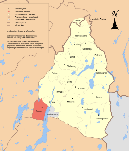
English: Map showing the borders of the civil parish of Brunn in the hundred of Redväg, Älvsborg County, Västergötland Region of Sweden. Circa 1850-1900. |
| Date | (UTC) |
| Source | |
| Author |
|
| This is a retouched picture, which means that it has been digitally altered from its original version. Modifications: Combined maps to show Redvägs härad. The original can be viewed here: GS Ulricehamn.svg:
|
This file is licensed under the Creative Commons Attribution-Share Alike 3.0 Unported license.
- You are free:
- to share – to copy, distribute and transmit the work
- to remix – to adapt the work
- Under the following conditions:
- attribution – You must give appropriate credit, provide a link to the license, and indicate if changes were made. You may do so in any reasonable manner, but not in any way that suggests the licensor endorses you or your use.
- share alike – If you remix, transform, or build upon the material, you must distribute your contributions under the same or compatible license as the original.
Original upload log[edit]
This image is a derivative work of the following images:
- File:GS_Skara.svg licensed with Cc-by-3.0
- 2010-10-05T12:29:40Z Edaen 5985x4458 (553110 Bytes) {{Information |other_versions={{DerivativeVersions|Torna härad.svg}} |Description={{en|1=Map showing borders of parishes and hundreds in the vicinity of Skara, based on information from map by Generalstaben. '''43. Skara''
- File:GS_Ulricehamn.svg licensed with Cc-by-3.0
- 2010-09-08T17:56:30Z Edaen 5933x4385 (392081 Bytes) {{Information |Description={{en|1=Map showing borders of parishes and hundreds in the vicinity of Ulricehamn, based on information from map by Generalstaben. '''34. Ulricehamn''' Generalstabens karta öfver Sverige 1885. Up
File history
Click on a date/time to view the file as it appeared at that time.
| Date/Time | Thumbnail | Dimensions | User | Comment | |
|---|---|---|---|---|---|
| current | 12:35, 5 October 2010 | | 4,198 × 4,906 (432 KB) | Edaen (talk | contribs) | {{Information |Description={{en|1=Map showing borders of parishes and hundreds in the vicinity of Skara, based on information from map by Generalstaben. <small>'''43. Skara''' Generalstabens karta öfver Sverige 1887. Uppmätt åren 1880-1881</small>}} |
You cannot overwrite this file.
File usage on Commons
The following 2 pages use this file:
File usage on other wikis
The following other wikis use this file:
- Usage on sv.wikipedia.org
- Usage on www.wikidata.org